You are here: Home > Network List > TA - USArray Transportable Network (new EarthScope stations) Stations List
> Station POKR Poker Plat Research Range, AK, USA > Earthquake Result Viewer
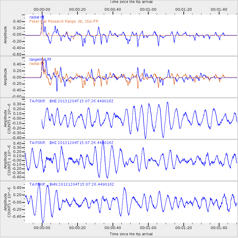
POKR Poker Plat Research Range, AK, USA - Earthquake Result Viewer
*The percent match for this event was below the threshold and hence no stack was calculated.
| Earthquake location: |
South Of Fiji Islands |
| Earthquake latitude/longitude: |
-25.4/178.3 |
| Earthquake time(UTC): |
2013/12/04 (338) 14:55:40 GMT |
| Earthquake Depth: |
574 km |
| Earthquake Magnitude: |
5.7 MWW, 5.8 MWB, 5.8 MWC |
| Earthquake Catalog/Contributor: |
NEIC PDE/NEIC COMCAT |
|
| Network: |
TA USArray Transportable Network (new EarthScope stations) |
| Station: |
POKR Poker Plat Research Range, AK, USA |
| Lat/Lon: |
65.12 N/147.43 W |
| Elevation: |
501 m |
|
| Distance: |
94.1 deg |
| Az: |
13.834 deg |
| Baz: |
210.728 deg |
| Ray Param: |
$rayparam |
*The percent match for this event was below the threshold and hence was not used in the summary stack. |
|
| Radial Match: |
42.927834 % |
| Radial Bump: |
361 |
| Transverse Match: |
59.046066 % |
| Transverse Bump: |
400 |
| SOD ConfigId: |
626651 |
| Insert Time: |
2014-04-19 23:20:32.794 +0000 |
| GWidth: |
2.5 |
| Max Bumps: |
400 |
| Tol: |
0.001 |
|
Signal To Noise
| Channel | StoN | STA | LTA |
| TA:POKR: :BHZ:20131204T15:07:26.449016Z | 1.2120309 | 1.3701192E-7 | 1.13043264E-7 |
| TA:POKR: :BHN:20131204T15:07:26.449016Z | 1.801094 | 3.5292018E-7 | 1.9594766E-7 |
| TA:POKR: :BHE:20131204T15:07:26.449016Z | 0.95928216 | 1.0453426E-7 | 1.08971335E-7 |
| Arrivals |
| Ps | |
| PpPs | |
| PsPs/PpSs | |


