You are here: Home > Network List > CB - China National Seismic Network Stations List
> Station GTA Gaotai,Gansu Province > Earthquake Result Viewer
GTA Gaotai,Gansu Province - Earthquake Result Viewer
| Earthquake location: |
Kuril Islands |
| Earthquake latitude/longitude: |
44.4/149.2 |
| Earthquake time(UTC): |
2013/12/08 (342) 17:24:54 GMT |
| Earthquake Depth: |
28 km |
| Earthquake Magnitude: |
6.0 MWW, 5.9 MWB, 6.1 MWC |
| Earthquake Catalog/Contributor: |
NEIC PDE/NEIC COMCAT |
|
| Network: |
CB China National Seismic Network |
| Station: |
GTA Gaotai,Gansu Province |
| Lat/Lon: |
39.40 N/99.82 E |
| Elevation: |
1345 m |
|
| Distance: |
36.6 deg |
| Az: |
279.712 deg |
| Baz: |
65.673 deg |
| Ray Param: |
0.07653832 |
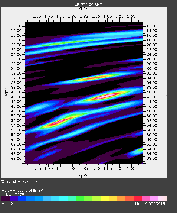
| Estimated Moho Depth: |
41.5 km |
| Estimated Crust Vp/Vs: |
1.94 |
| Assumed Crust Vp: |
6.491 km/s |
| Estimated Crust Vs: |
3.35 km/s |
| Estimated Crust Poisson's Ratio: |
0.32 |
|
| Radial Match: |
94.74744 % |
| Radial Bump: |
303 |
| Transverse Match: |
79.750565 % |
| Transverse Bump: |
400 |
| SOD ConfigId: |
626651 |
| Insert Time: |
2014-04-19 23:32:12.095 +0000 |
| GWidth: |
2.5 |
| Max Bumps: |
400 |
| Tol: |
0.001 |
|

Signal To Noise
| Channel | StoN | STA | LTA |
| CB:GTA:00:BHZ:20131208T17:31:27.379993Z | 19.297617 | 4.9908596E-7 | 2.5862569E-8 |
| CB:GTA:00:BHN:20131208T17:31:27.379993Z | 4.7187448 | 1.3234845E-7 | 2.8047385E-8 |
| CB:GTA:00:BHE:20131208T17:31:27.379993Z | 12.819541 | 2.6646006E-7 | 2.078546E-8 |
| Arrivals |
| Ps | 6.4 SECOND |
| PpPs | 18 SECOND |
| PsPs/PpSs | 24 SECOND |


