You are here: Home > Network List > TA - USArray Transportable Network (new EarthScope stations) Stations List
> Station D51A Lot 18 Range III Mazenod Township, QC, CAN > Earthquake Result Viewer
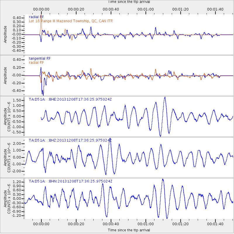
D51A Lot 18 Range III Mazenod Township, QC, CAN - Earthquake Result Viewer
*The percent match for this event was below the threshold and hence no stack was calculated.
| Earthquake location: |
Kuril Islands |
| Earthquake latitude/longitude: |
44.4/149.2 |
| Earthquake time(UTC): |
2013/12/08 (342) 17:24:54 GMT |
| Earthquake Depth: |
28 km |
| Earthquake Magnitude: |
6.0 MWW, 5.9 MWB, 6.1 MWC |
| Earthquake Catalog/Contributor: |
NEIC PDE/NEIC COMCAT |
|
| Network: |
TA USArray Transportable Network (new EarthScope stations) |
| Station: |
D51A Lot 18 Range III Mazenod Township, QC, CAN |
| Lat/Lon: |
47.09 N/79.37 W |
| Elevation: |
282 m |
|
| Distance: |
79.3 deg |
| Az: |
31.407 deg |
| Baz: |
326.888 deg |
| Ray Param: |
$rayparam |
*The percent match for this event was below the threshold and hence was not used in the summary stack. |
|
| Radial Match: |
52.14687 % |
| Radial Bump: |
400 |
| Transverse Match: |
87.11066 % |
| Transverse Bump: |
400 |
| SOD ConfigId: |
626651 |
| Insert Time: |
2014-04-19 23:52:46.248 +0000 |
| GWidth: |
2.5 |
| Max Bumps: |
400 |
| Tol: |
0.001 |
|
Signal To Noise
| Channel | StoN | STA | LTA |
| TA:D51A: :BHZ:20131208T17:36:25.975024Z | 1.8181825 | 1.0950499E-6 | 6.022772E-7 |
| TA:D51A: :BHN:20131208T17:36:25.975024Z | 1.671799 | 4.3262224E-7 | 2.5877648E-7 |
| TA:D51A: :BHE:20131208T17:36:25.975024Z | 1.7692696 | 6.794398E-7 | 3.8402277E-7 |
| Arrivals |
| Ps | |
| PpPs | |
| PsPs/PpSs | |


