You are here: Home > Network List > TA - USArray Transportable Network (new EarthScope stations) Stations List
> Station N02D Trinity Center, CA, USA > Earthquake Result Viewer
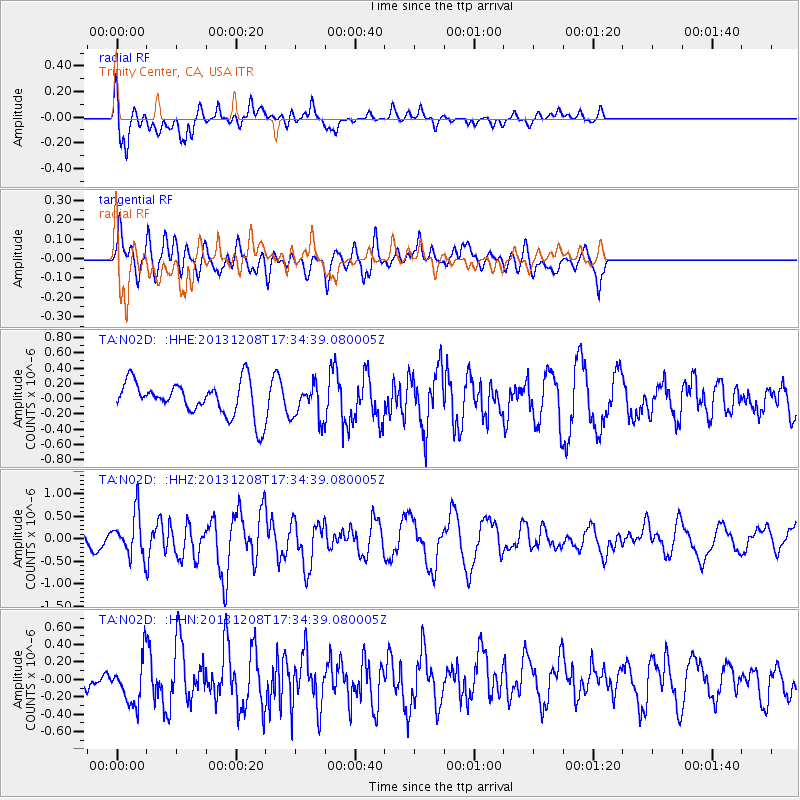
N02D Trinity Center, CA, USA - Earthquake Result Viewer
*The percent match for this event was below the threshold and hence no stack was calculated.
| Earthquake location: |
Kuril Islands |
| Earthquake latitude/longitude: |
44.4/149.2 |
| Earthquake time(UTC): |
2013/12/08 (342) 17:24:54 GMT |
| Earthquake Depth: |
28 km |
| Earthquake Magnitude: |
6.0 MWW, 5.9 MWB, 6.1 MWC |
| Earthquake Catalog/Contributor: |
NEIC PDE/NEIC COMCAT |
|
| Network: |
TA USArray Transportable Network (new EarthScope stations) |
| Station: |
N02D Trinity Center, CA, USA |
| Lat/Lon: |
40.97 N/122.71 W |
| Elevation: |
937 m |
|
| Distance: |
61.7 deg |
| Az: |
59.228 deg |
| Baz: |
305.629 deg |
| Ray Param: |
$rayparam |
*The percent match for this event was below the threshold and hence was not used in the summary stack. |
|
| Radial Match: |
65.088615 % |
| Radial Bump: |
400 |
| Transverse Match: |
62.87003 % |
| Transverse Bump: |
400 |
| SOD ConfigId: |
626651 |
| Insert Time: |
2014-04-19 23:59:47.572 +0000 |
| GWidth: |
2.5 |
| Max Bumps: |
400 |
| Tol: |
0.001 |
|
Signal To Noise
| Channel | StoN | STA | LTA |
| TA:N02D: :HHZ:20131208T17:34:39.080005Z | 2.5397167 | 4.6128648E-7 | 1.8162909E-7 |
| TA:N02D: :HHN:20131208T17:34:39.080005Z | 1.0772082 | 2.47744E-7 | 2.2998712E-7 |
| TA:N02D: :HHE:20131208T17:34:39.080005Z | 1.0033865 | 2.2273736E-7 | 2.2198559E-7 |
| Arrivals |
| Ps | |
| PpPs | |
| PsPs/PpSs | |


