You are here: Home > Network List > II - Global Seismograph Network (GSN - IRIS/IDA) Stations List
> Station KIV Kislovodsk, Russia > Earthquake Result Viewer
KIV Kislovodsk, Russia - Earthquake Result Viewer

| Earthquake location: |
Kuril Islands |
| Earthquake latitude/longitude: |
44.3/150.0 |
| Earthquake time(UTC): |
2002/10/19 (292) 12:09:05 GMT |
| Earthquake Depth: |
33 km |
| Earthquake Magnitude: |
5.4 MB, 6.2 MS, 6.4 MW, 6.1 MW |
| Earthquake Catalog/Contributor: |
WHDF/NEIC |
|
| Network: |
II Global Seismograph Network (GSN - IRIS/IDA) |
| Station: |
KIV Kislovodsk, Russia |
| Lat/Lon: |
43.96 N/42.69 E |
| Elevation: |
1054 m |
|
| Distance: |
70.9 deg |
| Az: |
313.126 deg |
| Baz: |
46.525 deg |
| Ray Param: |
0.05463413 |
| Estimated Moho Depth: |
29.75 km |
| Estimated Crust Vp/Vs: |
1.61 |
| Assumed Crust Vp: |
6.247 km/s |
| Estimated Crust Vs: |
3.886 km/s |
| Estimated Crust Poisson's Ratio: |
0.18 |
|
| Radial Match: |
98.571976 % |
| Radial Bump: |
282 |
| Transverse Match: |
93.881165 % |
| Transverse Bump: |
400 |
| SOD ConfigId: |
4714 |
| Insert Time: |
2010-03-01 18:11:30.403 +0000 |
| GWidth: |
2.5 |
| Max Bumps: |
400 |
| Tol: |
0.001 |
|
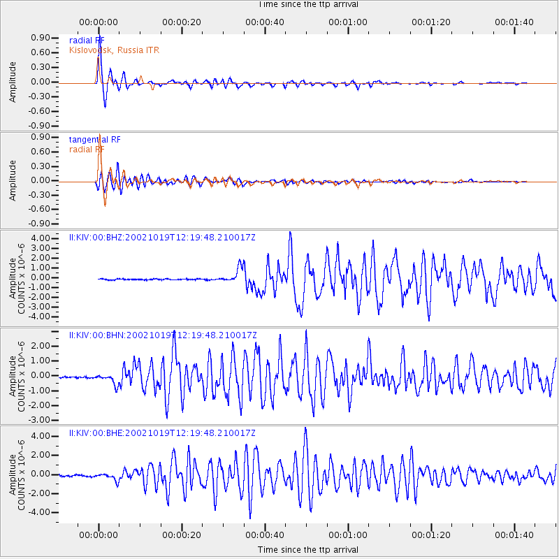
Signal To Noise
| Channel | StoN | STA | LTA |
| II:KIV:00:BHN:20021019T12:19:48.210017Z | 6.23271 | 3.6508646E-7 | 5.8575882E-8 |
| II:KIV:00:BHE:20021019T12:19:48.210017Z | 5.621988 | 3.764401E-7 | 6.695854E-8 |
| II:KIV:00:BHZ:20021019T12:19:48.210017Z | 16.896112 | 7.927724E-7 | 4.6920405E-8 |
| Arrivals |
| Ps | 3.0 SECOND |
| PpPs | 12 SECOND |
| PsPs/PpSs | 15 SECOND |


