You are here: Home > Network List > TA - USArray Transportable Network (new EarthScope stations) Stations List
> Station S59A Mechanicsville, VA, USA > Earthquake Result Viewer
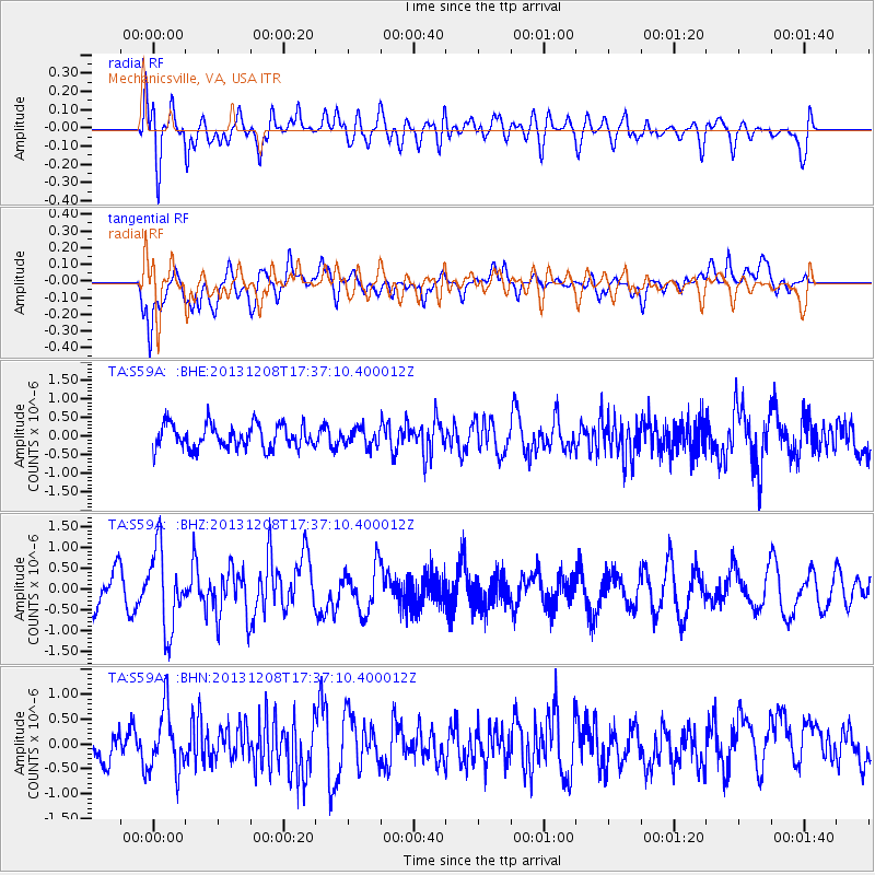
S59A Mechanicsville, VA, USA - Earthquake Result Viewer
*The percent match for this event was below the threshold and hence no stack was calculated.
| Earthquake location: |
Kuril Islands |
| Earthquake latitude/longitude: |
44.4/149.2 |
| Earthquake time(UTC): |
2013/12/08 (342) 17:24:54 GMT |
| Earthquake Depth: |
28 km |
| Earthquake Magnitude: |
6.0 MWW, 5.9 MWB, 6.1 MWC |
| Earthquake Catalog/Contributor: |
NEIC PDE/NEIC COMCAT |
|
| Network: |
TA USArray Transportable Network (new EarthScope stations) |
| Station: |
S59A Mechanicsville, VA, USA |
| Lat/Lon: |
37.46 N/77.18 W |
| Elevation: |
40 m |
|
| Distance: |
88.3 deg |
| Az: |
35.168 deg |
| Baz: |
328.772 deg |
| Ray Param: |
$rayparam |
*The percent match for this event was below the threshold and hence was not used in the summary stack. |
|
| Radial Match: |
60.268406 % |
| Radial Bump: |
400 |
| Transverse Match: |
69.467865 % |
| Transverse Bump: |
400 |
| SOD ConfigId: |
626651 |
| Insert Time: |
2014-04-20 00:03:19.797 +0000 |
| GWidth: |
2.5 |
| Max Bumps: |
400 |
| Tol: |
0.001 |
|
Signal To Noise
| Channel | StoN | STA | LTA |
| TA:S59A: :BHZ:20131208T17:37:10.400012Z | 1.5863255 | 9.644203E-7 | 6.0795867E-7 |
| TA:S59A: :BHN:20131208T17:37:10.400012Z | 1.3709441 | 6.0116145E-7 | 4.3850176E-7 |
| TA:S59A: :BHE:20131208T17:37:10.400012Z | 0.93345994 | 2.9236833E-7 | 3.1320928E-7 |
| Arrivals |
| Ps | |
| PpPs | |
| PsPs/PpSs | |


