You are here: Home > Network List > TA - USArray Transportable Network (new EarthScope stations) Stations List
> Station T52A Hallie, KY, USA > Earthquake Result Viewer
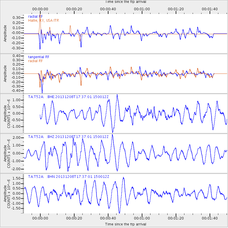
T52A Hallie, KY, USA - Earthquake Result Viewer
*The percent match for this event was below the threshold and hence no stack was calculated.
| Earthquake location: |
Kuril Islands |
| Earthquake latitude/longitude: |
44.4/149.2 |
| Earthquake time(UTC): |
2013/12/08 (342) 17:24:54 GMT |
| Earthquake Depth: |
28 km |
| Earthquake Magnitude: |
6.0 MWW, 5.9 MWB, 6.1 MWC |
| Earthquake Catalog/Contributor: |
NEIC PDE/NEIC COMCAT |
|
| Network: |
TA USArray Transportable Network (new EarthScope stations) |
| Station: |
T52A Hallie, KY, USA |
| Lat/Lon: |
37.11 N/82.99 W |
| Elevation: |
436 m |
|
| Distance: |
86.1 deg |
| Az: |
39.252 deg |
| Baz: |
325.465 deg |
| Ray Param: |
$rayparam |
*The percent match for this event was below the threshold and hence was not used in the summary stack. |
|
| Radial Match: |
51.624104 % |
| Radial Bump: |
400 |
| Transverse Match: |
79.26746 % |
| Transverse Bump: |
400 |
| SOD ConfigId: |
626651 |
| Insert Time: |
2014-04-20 00:03:41.162 +0000 |
| GWidth: |
2.5 |
| Max Bumps: |
400 |
| Tol: |
0.001 |
|
Signal To Noise
| Channel | StoN | STA | LTA |
| TA:T52A: :BHZ:20131208T17:37:01.150012Z | 2.1829212 | 1.159952E-6 | 5.3137603E-7 |
| TA:T52A: :BHN:20131208T17:37:01.150012Z | 1.2471888 | 5.9327294E-7 | 4.7568815E-7 |
| TA:T52A: :BHE:20131208T17:37:01.150012Z | 0.8469503 | 3.3553317E-7 | 3.961663E-7 |
| Arrivals |
| Ps | |
| PpPs | |
| PsPs/PpSs | |


