You are here: Home > Network List > TA - USArray Transportable Network (new EarthScope stations) Stations List
> Station Z41A Richland Creek Farm, El Dorado, AR, USA > Earthquake Result Viewer
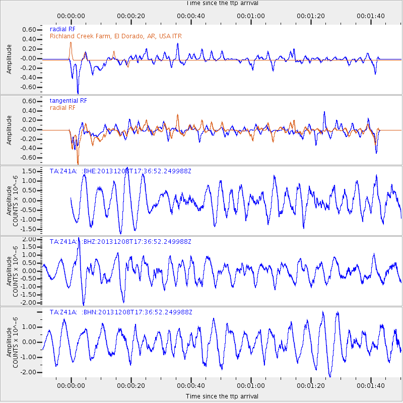
Z41A Richland Creek Farm, El Dorado, AR, USA - Earthquake Result Viewer
*The percent match for this event was below the threshold and hence no stack was calculated.
| Earthquake location: |
Kuril Islands |
| Earthquake latitude/longitude: |
44.4/149.2 |
| Earthquake time(UTC): |
2013/12/08 (342) 17:24:54 GMT |
| Earthquake Depth: |
28 km |
| Earthquake Magnitude: |
6.0 MWW, 5.9 MWB, 6.1 MWC |
| Earthquake Catalog/Contributor: |
NEIC PDE/NEIC COMCAT |
|
| Network: |
TA USArray Transportable Network (new EarthScope stations) |
| Station: |
Z41A Richland Creek Farm, El Dorado, AR, USA |
| Lat/Lon: |
33.26 N/92.80 W |
| Elevation: |
62 m |
|
| Distance: |
84.3 deg |
| Az: |
48.009 deg |
| Baz: |
320.552 deg |
| Ray Param: |
$rayparam |
*The percent match for this event was below the threshold and hence was not used in the summary stack. |
|
| Radial Match: |
57.64131 % |
| Radial Bump: |
400 |
| Transverse Match: |
60.03885 % |
| Transverse Bump: |
375 |
| SOD ConfigId: |
626651 |
| Insert Time: |
2014-04-20 00:06:04.071 +0000 |
| GWidth: |
2.5 |
| Max Bumps: |
400 |
| Tol: |
0.001 |
|
Signal To Noise
| Channel | StoN | STA | LTA |
| TA:Z41A: :BHZ:20131208T17:36:52.249988Z | 4.012207 | 1.1715393E-6 | 2.9199373E-7 |
| TA:Z41A: :BHN:20131208T17:36:52.249988Z | 0.84261143 | 7.1569286E-7 | 8.4937477E-7 |
| TA:Z41A: :BHE:20131208T17:36:52.249988Z | 0.3839826 | 3.5073734E-7 | 9.1341985E-7 |
| Arrivals |
| Ps | |
| PpPs | |
| PsPs/PpSs | |


