You are here: Home > Network List > TA - USArray Transportable Network (new EarthScope stations) Stations List
> Station Z50A Ashland, AL, USA > Earthquake Result Viewer
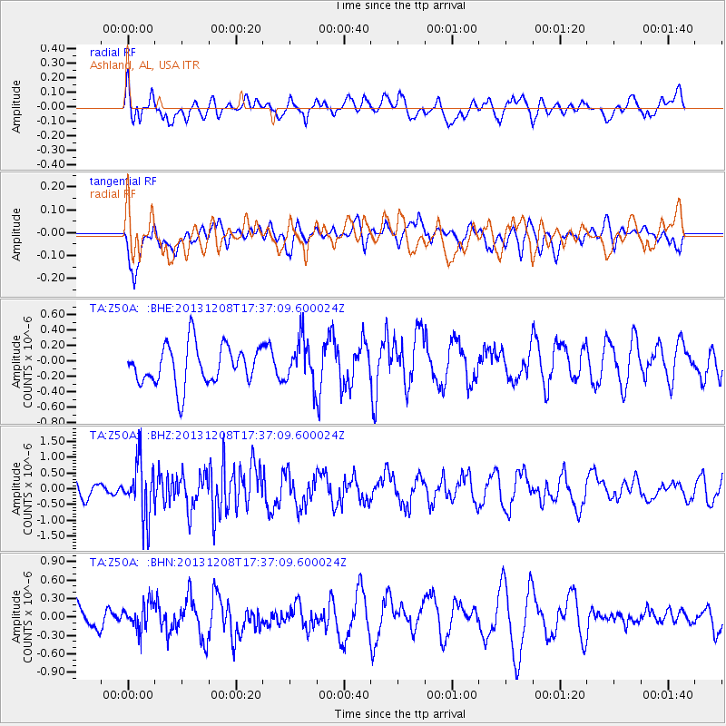
Z50A Ashland, AL, USA - Earthquake Result Viewer
*The percent match for this event was below the threshold and hence no stack was calculated.
| Earthquake location: |
Kuril Islands |
| Earthquake latitude/longitude: |
44.4/149.2 |
| Earthquake time(UTC): |
2013/12/08 (342) 17:24:54 GMT |
| Earthquake Depth: |
28 km |
| Earthquake Magnitude: |
6.0 MWW, 5.9 MWB, 6.1 MWC |
| Earthquake Catalog/Contributor: |
NEIC PDE/NEIC COMCAT |
|
| Network: |
TA USArray Transportable Network (new EarthScope stations) |
| Station: |
Z50A Ashland, AL, USA |
| Lat/Lon: |
33.25 N/85.92 W |
| Elevation: |
370 m |
|
| Distance: |
87.9 deg |
| Az: |
43.442 deg |
| Baz: |
323.999 deg |
| Ray Param: |
$rayparam |
*The percent match for this event was below the threshold and hence was not used in the summary stack. |
|
| Radial Match: |
46.663578 % |
| Radial Bump: |
400 |
| Transverse Match: |
58.77423 % |
| Transverse Bump: |
400 |
| SOD ConfigId: |
626651 |
| Insert Time: |
2014-04-20 00:06:04.364 +0000 |
| GWidth: |
2.5 |
| Max Bumps: |
400 |
| Tol: |
0.001 |
|
Signal To Noise
| Channel | StoN | STA | LTA |
| TA:Z50A: :BHZ:20131208T17:37:09.600024Z | 4.9311924 | 8.939183E-7 | 1.8127832E-7 |
| TA:Z50A: :BHN:20131208T17:37:09.600024Z | 1.0121826 | 2.189409E-7 | 2.1630572E-7 |
| TA:Z50A: :BHE:20131208T17:37:09.600024Z | 1.1040564 | 2.8223664E-7 | 2.5563608E-7 |
| Arrivals |
| Ps | |
| PpPs | |
| PsPs/PpSs | |


