You are here: Home > Network List > US - United States National Seismic Network Stations List
> Station ERPA Erie, Pennsylvania, USA > Earthquake Result Viewer
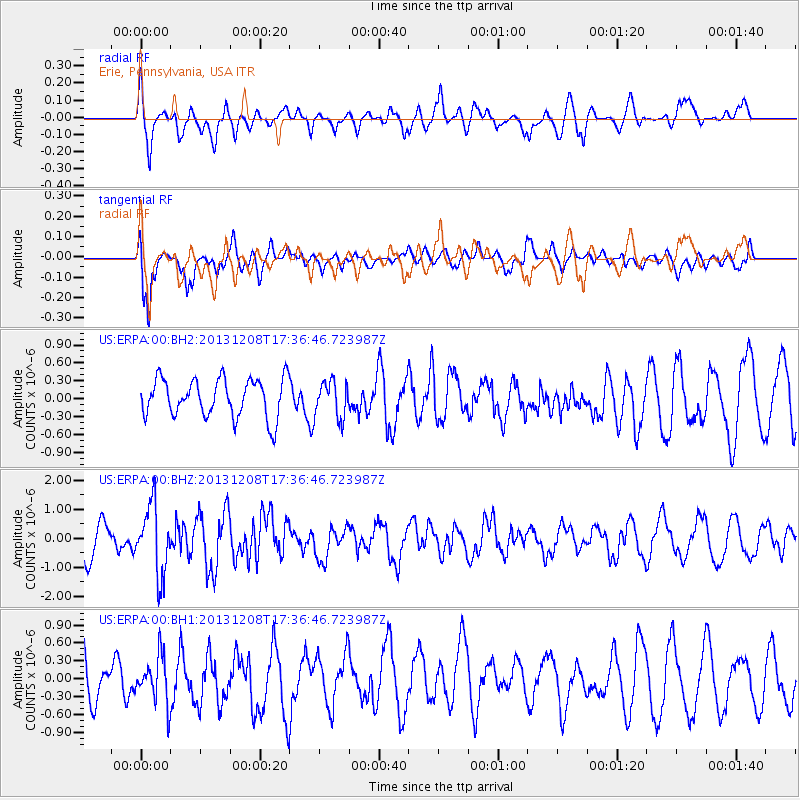
ERPA Erie, Pennsylvania, USA - Earthquake Result Viewer
*The percent match for this event was below the threshold and hence no stack was calculated.
| Earthquake location: |
Kuril Islands |
| Earthquake latitude/longitude: |
44.4/149.2 |
| Earthquake time(UTC): |
2013/12/08 (342) 17:24:54 GMT |
| Earthquake Depth: |
28 km |
| Earthquake Magnitude: |
6.0 MWW, 5.9 MWB, 6.1 MWC |
| Earthquake Catalog/Contributor: |
NEIC PDE/NEIC COMCAT |
|
| Network: |
US United States National Seismic Network |
| Station: |
ERPA Erie, Pennsylvania, USA |
| Lat/Lon: |
42.12 N/79.99 W |
| Elevation: |
306 m |
|
| Distance: |
83.2 deg |
| Az: |
34.526 deg |
| Baz: |
326.93 deg |
| Ray Param: |
$rayparam |
*The percent match for this event was below the threshold and hence was not used in the summary stack. |
|
| Radial Match: |
59.377052 % |
| Radial Bump: |
400 |
| Transverse Match: |
74.43504 % |
| Transverse Bump: |
400 |
| SOD ConfigId: |
626651 |
| Insert Time: |
2014-04-20 00:07:39.248 +0000 |
| GWidth: |
2.5 |
| Max Bumps: |
400 |
| Tol: |
0.001 |
|
Signal To Noise
| Channel | StoN | STA | LTA |
| US:ERPA:00:BHZ:20131208T17:36:46.723987Z | 2.1343102 | 1.2006291E-6 | 5.6253725E-7 |
| US:ERPA:00:BH1:20131208T17:36:46.723987Z | 0.8850914 | 3.8533923E-7 | 4.353666E-7 |
| US:ERPA:00:BH2:20131208T17:36:46.723987Z | 0.96501917 | 3.090245E-7 | 3.202263E-7 |
| Arrivals |
| Ps | |
| PpPs | |
| PsPs/PpSs | |


