You are here: Home > Network List > TA - USArray Transportable Network (new EarthScope stations) Stations List
> Station I23K Minto, Yukon-Koyukuk, AK, USA > Earthquake Result Viewer
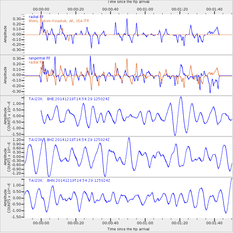
I23K Minto, Yukon-Koyukuk, AK, USA - Earthquake Result Viewer
*The percent match for this event was below the threshold and hence no stack was calculated.
| Earthquake location: |
Nicobar Islands, India Region |
| Earthquake latitude/longitude: |
6.9/94.6 |
| Earthquake time(UTC): |
2014/12/19 (353) 14:41:44 GMT |
| Earthquake Depth: |
37 km |
| Earthquake Magnitude: |
5.5 MW, 5.3 mb, 5.0 MS |
| Earthquake Catalog/Contributor: |
ISC/ISC |
|
| Network: |
TA USArray Transportable Network (new EarthScope stations) |
| Station: |
I23K Minto, Yukon-Koyukuk, AK, USA |
| Lat/Lon: |
65.15 N/149.36 W |
| Elevation: |
149 m |
|
| Distance: |
94.4 deg |
| Az: |
22.389 deg |
| Baz: |
296.504 deg |
| Ray Param: |
$rayparam |
*The percent match for this event was below the threshold and hence was not used in the summary stack. |
|
| Radial Match: |
57.860664 % |
| Radial Bump: |
400 |
| Transverse Match: |
63.319527 % |
| Transverse Bump: |
400 |
| SOD ConfigId: |
3390531 |
| Insert Time: |
2019-04-15 15:47:45.794 +0000 |
| GWidth: |
2.5 |
| Max Bumps: |
400 |
| Tol: |
0.001 |
|
Signal To Noise
| Channel | StoN | STA | LTA |
| TA:I23K: :BHZ:20141219T14:54:29.125024Z | 1.9268765 | 9.886978E-7 | 5.1310906E-7 |
| TA:I23K: :BHN:20141219T14:54:29.125024Z | 1.7870218 | 6.1377E-7 | 3.4345973E-7 |
| TA:I23K: :BHE:20141219T14:54:29.125024Z | 1.0042677 | 4.5801485E-7 | 4.5606848E-7 |
| Arrivals |
| Ps | |
| PpPs | |
| PsPs/PpSs | |


