You are here: Home > Network List > US - United States National Seismic Network Stations List
> Station WUAZ Wupatki, Arizona, USA > Earthquake Result Viewer
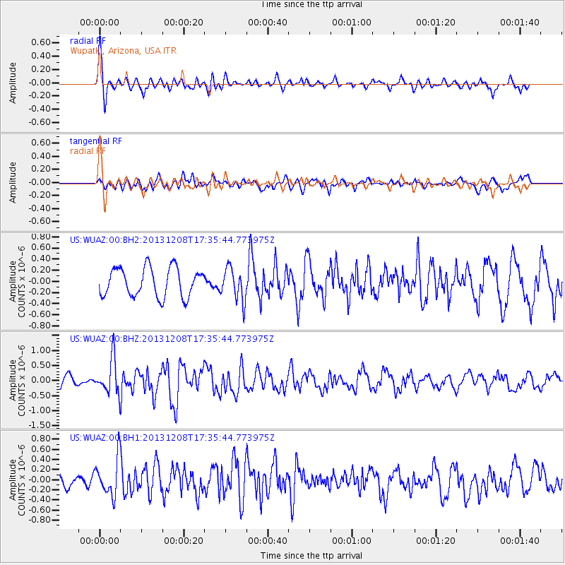
WUAZ Wupatki, Arizona, USA - Earthquake Result Viewer
*The percent match for this event was below the threshold and hence no stack was calculated.
| Earthquake location: |
Kuril Islands |
| Earthquake latitude/longitude: |
44.4/149.2 |
| Earthquake time(UTC): |
2013/12/08 (342) 17:24:54 GMT |
| Earthquake Depth: |
28 km |
| Earthquake Magnitude: |
6.0 MWW, 5.9 MWB, 6.1 MWC |
| Earthquake Catalog/Contributor: |
NEIC PDE/NEIC COMCAT |
|
| Network: |
US United States National Seismic Network |
| Station: |
WUAZ Wupatki, Arizona, USA |
| Lat/Lon: |
35.52 N/111.37 W |
| Elevation: |
1592 m |
|
| Distance: |
72.1 deg |
| Az: |
57.745 deg |
| Baz: |
312.052 deg |
| Ray Param: |
$rayparam |
*The percent match for this event was below the threshold and hence was not used in the summary stack. |
|
| Radial Match: |
73.7181 % |
| Radial Bump: |
400 |
| Transverse Match: |
61.232235 % |
| Transverse Bump: |
400 |
| SOD ConfigId: |
626651 |
| Insert Time: |
2014-04-20 00:08:51.483 +0000 |
| GWidth: |
2.5 |
| Max Bumps: |
400 |
| Tol: |
0.001 |
|
Signal To Noise
| Channel | StoN | STA | LTA |
| US:WUAZ:00:BHZ:20131208T17:35:44.773975Z | 3.4055355 | 5.9527395E-7 | 1.74796E-7 |
| US:WUAZ:00:BH1:20131208T17:35:44.773975Z | 2.0699363 | 3.744821E-7 | 1.809148E-7 |
| US:WUAZ:00:BH2:20131208T17:35:44.773975Z | 1.159317 | 2.982851E-7 | 2.5729383E-7 |
| Arrivals |
| Ps | |
| PpPs | |
| PsPs/PpSs | |


