You are here: Home > Network List > UW - Pacific Northwest Regional Seismic Network Stations List
> Station MRBL Marblemount, WA, USA > Earthquake Result Viewer
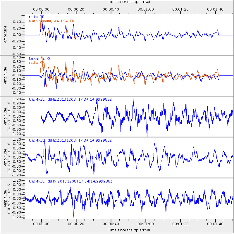
MRBL Marblemount, WA, USA - Earthquake Result Viewer
*The percent match for this event was below the threshold and hence no stack was calculated.
| Earthquake location: |
Kuril Islands |
| Earthquake latitude/longitude: |
44.4/149.2 |
| Earthquake time(UTC): |
2013/12/08 (342) 17:24:54 GMT |
| Earthquake Depth: |
28 km |
| Earthquake Magnitude: |
6.0 MWW, 5.9 MWB, 6.1 MWC |
| Earthquake Catalog/Contributor: |
NEIC PDE/NEIC COMCAT |
|
| Network: |
UW Pacific Northwest Regional Seismic Network |
| Station: |
MRBL Marblemount, WA, USA |
| Lat/Lon: |
48.52 N/121.48 W |
| Elevation: |
75 m |
|
| Distance: |
58.2 deg |
| Az: |
51.451 deg |
| Baz: |
302.59 deg |
| Ray Param: |
$rayparam |
*The percent match for this event was below the threshold and hence was not used in the summary stack. |
|
| Radial Match: |
55.826283 % |
| Radial Bump: |
400 |
| Transverse Match: |
45.120968 % |
| Transverse Bump: |
400 |
| SOD ConfigId: |
626651 |
| Insert Time: |
2014-04-20 00:10:47.813 +0000 |
| GWidth: |
2.5 |
| Max Bumps: |
400 |
| Tol: |
0.001 |
|
Signal To Noise
| Channel | StoN | STA | LTA |
| UW:MRBL: :BHZ:20131208T17:34:14.999988Z | 3.9300086 | 6.2755174E-7 | 1.5968202E-7 |
| UW:MRBL: :BHN:20131208T17:34:14.999988Z | 1.4646294 | 1.8109678E-7 | 1.2364681E-7 |
| UW:MRBL: :BHE:20131208T17:34:14.999988Z | 2.7964756 | 5.619203E-7 | 2.0093874E-7 |
| Arrivals |
| Ps | |
| PpPs | |
| PsPs/PpSs | |


