You are here: Home > Network List > TA - USArray Transportable Network (new EarthScope stations) Stations List
> Station G59A Clarenceville, QC, USA > Earthquake Result Viewer
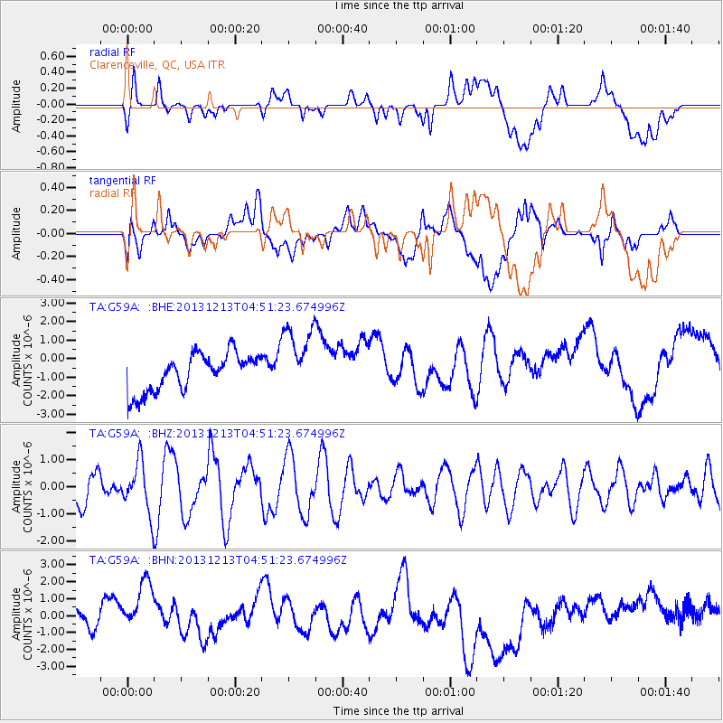
G59A Clarenceville, QC, USA - Earthquake Result Viewer
*The percent match for this event was below the threshold and hence no stack was calculated.
| Earthquake location: |
El Salvador |
| Earthquake latitude/longitude: |
13.1/-89.1 |
| Earthquake time(UTC): |
2013/12/13 (347) 04:45:11 GMT |
| Earthquake Depth: |
68 km |
| Earthquake Magnitude: |
5.6 MWB, 5.5 MWC |
| Earthquake Catalog/Contributor: |
NEIC PDE/NEIC COMCAT |
|
| Network: |
TA USArray Transportable Network (new EarthScope stations) |
| Station: |
G59A Clarenceville, QC, USA |
| Lat/Lon: |
45.08 N/73.18 W |
| Elevation: |
36 m |
|
| Distance: |
34.6 deg |
| Az: |
19.996 deg |
| Baz: |
208.047 deg |
| Ray Param: |
$rayparam |
*The percent match for this event was below the threshold and hence was not used in the summary stack. |
|
| Radial Match: |
19.390364 % |
| Radial Bump: |
400 |
| Transverse Match: |
38.156082 % |
| Transverse Bump: |
400 |
| SOD ConfigId: |
626651 |
| Insert Time: |
2014-04-20 00:27:18.629 +0000 |
| GWidth: |
2.5 |
| Max Bumps: |
400 |
| Tol: |
0.001 |
|
Signal To Noise
| Channel | StoN | STA | LTA |
| TA:G59A: :BHZ:20131213T04:51:23.674996Z | 1.3362479 | 9.491206E-7 | 7.102878E-7 |
| TA:G59A: :BHN:20131213T04:51:23.674996Z | 1.196493 | 2.5165014E-6 | 2.1032313E-6 |
| TA:G59A: :BHE:20131213T04:51:23.674996Z | 1.8676835 | 1.8831379E-6 | 1.0082746E-6 |
| Arrivals |
| Ps | |
| PpPs | |
| PsPs/PpSs | |


