You are here: Home > Network List > TA - USArray Transportable Network (new EarthScope stations) Stations List
> Station MDND Maddock, ND, USA > Earthquake Result Viewer
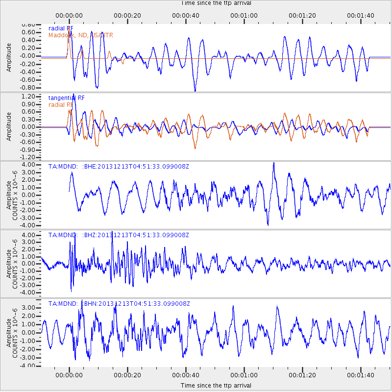
MDND Maddock, ND, USA - Earthquake Result Viewer
*The percent match for this event was below the threshold and hence no stack was calculated.
| Earthquake location: |
El Salvador |
| Earthquake latitude/longitude: |
13.1/-89.1 |
| Earthquake time(UTC): |
2013/12/13 (347) 04:45:11 GMT |
| Earthquake Depth: |
68 km |
| Earthquake Magnitude: |
5.6 MWB, 5.5 MWC |
| Earthquake Catalog/Contributor: |
NEIC PDE/NEIC COMCAT |
|
| Network: |
TA USArray Transportable Network (new EarthScope stations) |
| Station: |
MDND Maddock, ND, USA |
| Lat/Lon: |
47.85 N/99.60 W |
| Elevation: |
479 m |
|
| Distance: |
35.7 deg |
| Az: |
347.843 deg |
| Baz: |
162.267 deg |
| Ray Param: |
$rayparam |
*The percent match for this event was below the threshold and hence was not used in the summary stack. |
|
| Radial Match: |
59.514008 % |
| Radial Bump: |
400 |
| Transverse Match: |
74.22985 % |
| Transverse Bump: |
400 |
| SOD ConfigId: |
626651 |
| Insert Time: |
2014-04-20 00:29:44.476 +0000 |
| GWidth: |
2.5 |
| Max Bumps: |
400 |
| Tol: |
0.001 |
|
Signal To Noise
| Channel | StoN | STA | LTA |
| TA:MDND: :BHZ:20131213T04:51:33.099008Z | 2.2248843 | 1.5232125E-6 | 6.846255E-7 |
| TA:MDND: :BHN:20131213T04:51:33.099008Z | 1.2682002 | 1.7372688E-6 | 1.3698697E-6 |
| TA:MDND: :BHE:20131213T04:51:33.099008Z | 0.9294451 | 1.1996532E-6 | 1.2907198E-6 |
| Arrivals |
| Ps | |
| PpPs | |
| PsPs/PpSs | |


