You are here: Home > Network List > US - United States National Seismic Network Stations List
> Station LAO LASA Array, Montana, USA > Earthquake Result Viewer
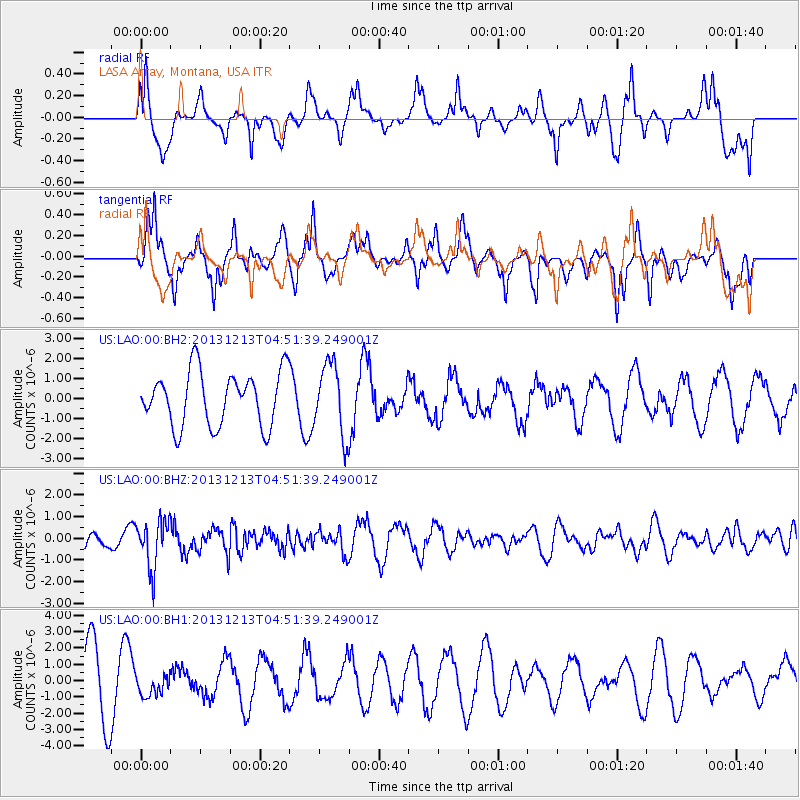
LAO LASA Array, Montana, USA - Earthquake Result Viewer
*The percent match for this event was below the threshold and hence no stack was calculated.
| Earthquake location: |
El Salvador |
| Earthquake latitude/longitude: |
13.1/-89.1 |
| Earthquake time(UTC): |
2013/12/13 (347) 04:45:11 GMT |
| Earthquake Depth: |
68 km |
| Earthquake Magnitude: |
5.6 MWB, 5.5 MWC |
| Earthquake Catalog/Contributor: |
NEIC PDE/NEIC COMCAT |
|
| Network: |
US United States National Seismic Network |
| Station: |
LAO LASA Array, Montana, USA |
| Lat/Lon: |
46.69 N/106.22 W |
| Elevation: |
902 m |
|
| Distance: |
36.4 deg |
| Az: |
340.029 deg |
| Baz: |
151.097 deg |
| Ray Param: |
$rayparam |
*The percent match for this event was below the threshold and hence was not used in the summary stack. |
|
| Radial Match: |
32.814926 % |
| Radial Bump: |
371 |
| Transverse Match: |
49.944576 % |
| Transverse Bump: |
362 |
| SOD ConfigId: |
626651 |
| Insert Time: |
2014-04-20 00:30:31.601 +0000 |
| GWidth: |
2.5 |
| Max Bumps: |
400 |
| Tol: |
0.001 |
|
Signal To Noise
| Channel | StoN | STA | LTA |
| US:LAO:00:BHZ:20131213T04:51:39.249001Z | 2.4641676 | 1.104862E-6 | 4.4837134E-7 |
| US:LAO:00:BH1:20131213T04:51:39.249001Z | 0.2570969 | 6.555505E-7 | 2.5498189E-6 |
| US:LAO:00:BH2:20131213T04:51:39.249001Z | 1.3137612 | 1.7870552E-6 | 1.3602588E-6 |
| Arrivals |
| Ps | |
| PpPs | |
| PsPs/PpSs | |


