You are here: Home > Network List > TA - USArray Transportable Network (new EarthScope stations) Stations List
> Station 121A Cookes Peak, Deming, NM, USA > Earthquake Result Viewer
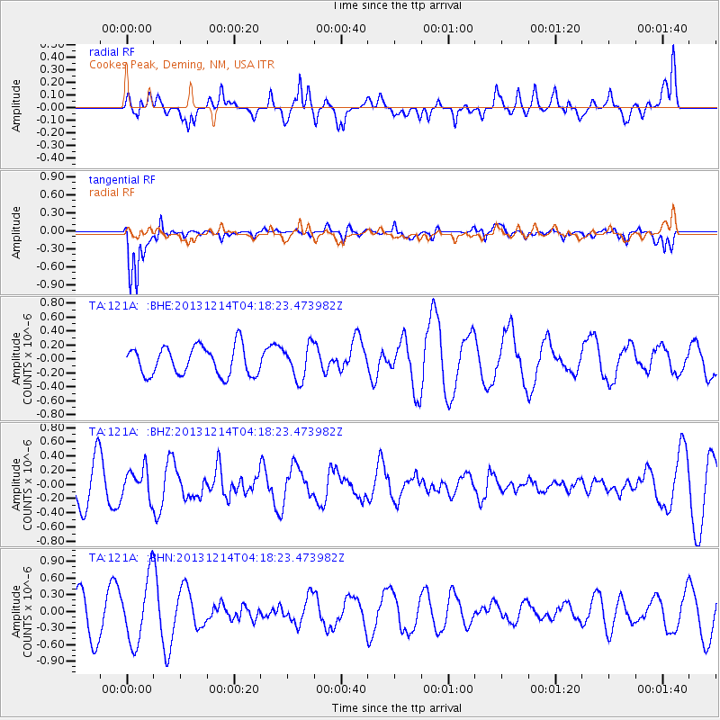
121A Cookes Peak, Deming, NM, USA - Earthquake Result Viewer
*The percent match for this event was below the threshold and hence no stack was calculated.
| Earthquake location: |
Near East Coast Of Honshu, Japan |
| Earthquake latitude/longitude: |
35.7/140.7 |
| Earthquake time(UTC): |
2013/12/14 (348) 04:06:15 GMT |
| Earthquake Depth: |
42 km |
| Earthquake Magnitude: |
5.5 MWB, 5.6 MWC |
| Earthquake Catalog/Contributor: |
NEIC PDE/NEIC COMCAT |
|
| Network: |
TA USArray Transportable Network (new EarthScope stations) |
| Station: |
121A Cookes Peak, Deming, NM, USA |
| Lat/Lon: |
32.53 N/107.79 W |
| Elevation: |
1652 m |
|
| Distance: |
86.7 deg |
| Az: |
51.9 deg |
| Baz: |
310.652 deg |
| Ray Param: |
$rayparam |
*The percent match for this event was below the threshold and hence was not used in the summary stack. |
|
| Radial Match: |
62.089836 % |
| Radial Bump: |
400 |
| Transverse Match: |
75.86949 % |
| Transverse Bump: |
400 |
| SOD ConfigId: |
626651 |
| Insert Time: |
2014-04-20 00:50:43.352 +0000 |
| GWidth: |
2.5 |
| Max Bumps: |
400 |
| Tol: |
0.001 |
|
Signal To Noise
| Channel | StoN | STA | LTA |
| TA:121A: :BHZ:20131214T04:18:23.473982Z | 0.6813419 | 2.0503822E-7 | 3.0093295E-7 |
| TA:121A: :BHN:20131214T04:18:23.473982Z | 1.6162981 | 5.9577246E-7 | 3.6860308E-7 |
| TA:121A: :BHE:20131214T04:18:23.473982Z | 1.1870184 | 2.433581E-7 | 2.0501628E-7 |
| Arrivals |
| Ps | |
| PpPs | |
| PsPs/PpSs | |


