You are here: Home > Network List > TA - USArray Transportable Network (new EarthScope stations) Stations List
> Station D62A Allapoint, Allagash, ME, USA > Earthquake Result Viewer
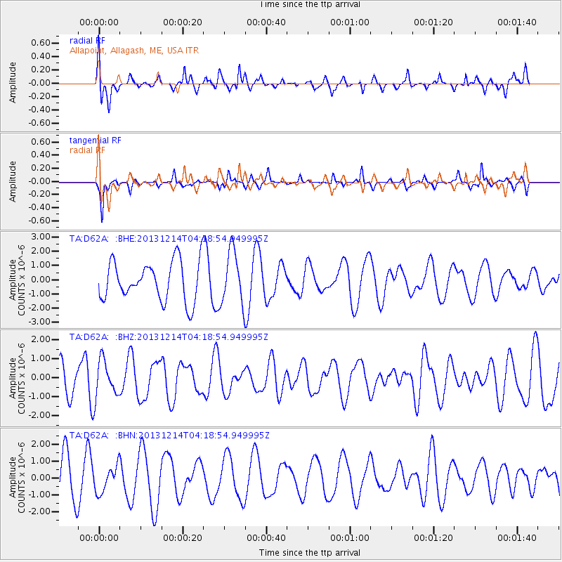
D62A Allapoint, Allagash, ME, USA - Earthquake Result Viewer
*The percent match for this event was below the threshold and hence no stack was calculated.
| Earthquake location: |
Near East Coast Of Honshu, Japan |
| Earthquake latitude/longitude: |
35.7/140.7 |
| Earthquake time(UTC): |
2013/12/14 (348) 04:06:15 GMT |
| Earthquake Depth: |
42 km |
| Earthquake Magnitude: |
5.5 MWB, 5.6 MWC |
| Earthquake Catalog/Contributor: |
NEIC PDE/NEIC COMCAT |
|
| Network: |
TA USArray Transportable Network (new EarthScope stations) |
| Station: |
D62A Allapoint, Allagash, ME, USA |
| Lat/Lon: |
47.08 N/69.05 W |
| Elevation: |
189 m |
|
| Distance: |
93.4 deg |
| Az: |
19.831 deg |
| Baz: |
336.154 deg |
| Ray Param: |
$rayparam |
*The percent match for this event was below the threshold and hence was not used in the summary stack. |
|
| Radial Match: |
64.50094 % |
| Radial Bump: |
297 |
| Transverse Match: |
69.84103 % |
| Transverse Bump: |
288 |
| SOD ConfigId: |
626651 |
| Insert Time: |
2014-04-20 00:51:16.434 +0000 |
| GWidth: |
2.5 |
| Max Bumps: |
400 |
| Tol: |
0.001 |
|
Signal To Noise
| Channel | StoN | STA | LTA |
| TA:D62A: :BHZ:20131214T04:18:54.949995Z | 0.8325539 | 9.0722057E-7 | 1.0896838E-6 |
| TA:D62A: :BHN:20131214T04:18:54.949995Z | 0.868918 | 7.9839276E-7 | 9.1883555E-7 |
| TA:D62A: :BHE:20131214T04:18:54.949995Z | 1.360728 | 1.8829883E-6 | 1.3838094E-6 |
| Arrivals |
| Ps | |
| PpPs | |
| PsPs/PpSs | |


