You are here: Home > Network List > TA - USArray Transportable Network (new EarthScope stations) Stations List
> Station H57A Richville, NY, USA > Earthquake Result Viewer
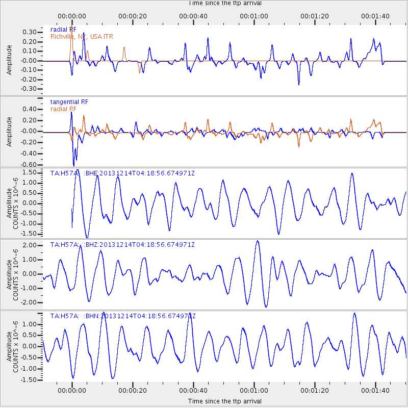
H57A Richville, NY, USA - Earthquake Result Viewer
*The percent match for this event was below the threshold and hence no stack was calculated.
| Earthquake location: |
Near East Coast Of Honshu, Japan |
| Earthquake latitude/longitude: |
35.7/140.7 |
| Earthquake time(UTC): |
2013/12/14 (348) 04:06:15 GMT |
| Earthquake Depth: |
42 km |
| Earthquake Magnitude: |
5.5 MWB, 5.6 MWC |
| Earthquake Catalog/Contributor: |
NEIC PDE/NEIC COMCAT |
|
| Network: |
TA USArray Transportable Network (new EarthScope stations) |
| Station: |
H57A Richville, NY, USA |
| Lat/Lon: |
44.46 N/75.39 W |
| Elevation: |
132 m |
|
| Distance: |
93.8 deg |
| Az: |
24.978 deg |
| Baz: |
331.297 deg |
| Ray Param: |
$rayparam |
*The percent match for this event was below the threshold and hence was not used in the summary stack. |
|
| Radial Match: |
72.03551 % |
| Radial Bump: |
400 |
| Transverse Match: |
86.35628 % |
| Transverse Bump: |
400 |
| SOD ConfigId: |
626651 |
| Insert Time: |
2014-04-20 00:52:28.344 +0000 |
| GWidth: |
2.5 |
| Max Bumps: |
400 |
| Tol: |
0.001 |
|
Signal To Noise
| Channel | StoN | STA | LTA |
| TA:H57A: :BHZ:20131214T04:18:56.674971Z | 1.4999925 | 1.1499698E-6 | 7.666503E-7 |
| TA:H57A: :BHN:20131214T04:18:56.674971Z | 1.9407663 | 8.5799104E-7 | 4.4208878E-7 |
| TA:H57A: :BHE:20131214T04:18:56.674971Z | 0.8831697 | 7.216229E-7 | 8.170829E-7 |
| Arrivals |
| Ps | |
| PpPs | |
| PsPs/PpSs | |


