You are here: Home > Network List > TA - USArray Transportable Network (new EarthScope stations) Stations List
> Station I48A Sherman Twp, MI, USA > Earthquake Result Viewer
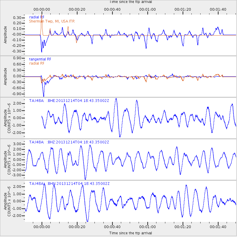
I48A Sherman Twp, MI, USA - Earthquake Result Viewer
*The percent match for this event was below the threshold and hence no stack was calculated.
| Earthquake location: |
Near East Coast Of Honshu, Japan |
| Earthquake latitude/longitude: |
35.7/140.7 |
| Earthquake time(UTC): |
2013/12/14 (348) 04:06:15 GMT |
| Earthquake Depth: |
42 km |
| Earthquake Magnitude: |
5.5 MWB, 5.6 MWC |
| Earthquake Catalog/Contributor: |
NEIC PDE/NEIC COMCAT |
|
| Network: |
TA USArray Transportable Network (new EarthScope stations) |
| Station: |
I48A Sherman Twp, MI, USA |
| Lat/Lon: |
44.19 N/83.70 W |
| Elevation: |
192 m |
|
| Distance: |
90.9 deg |
| Az: |
30.2 deg |
| Baz: |
325.289 deg |
| Ray Param: |
$rayparam |
*The percent match for this event was below the threshold and hence was not used in the summary stack. |
|
| Radial Match: |
45.785538 % |
| Radial Bump: |
400 |
| Transverse Match: |
89.17585 % |
| Transverse Bump: |
400 |
| SOD ConfigId: |
626651 |
| Insert Time: |
2014-04-20 00:52:51.951 +0000 |
| GWidth: |
2.5 |
| Max Bumps: |
400 |
| Tol: |
0.001 |
|
Signal To Noise
| Channel | StoN | STA | LTA |
| TA:I48A: :BHZ:20131214T04:18:43.35002Z | 1.1793299 | 1.3699145E-6 | 1.1616041E-6 |
| TA:I48A: :BHN:20131214T04:18:43.35002Z | 2.7465272 | 1.6092046E-6 | 5.859052E-7 |
| TA:I48A: :BHE:20131214T04:18:43.35002Z | 0.2509656 | 2.2094089E-7 | 8.8036325E-7 |
| Arrivals |
| Ps | |
| PpPs | |
| PsPs/PpSs | |


