You are here: Home > Network List > TA - USArray Transportable Network (new EarthScope stations) Stations List
> Station I55A Frankford, ON, CAN > Earthquake Result Viewer
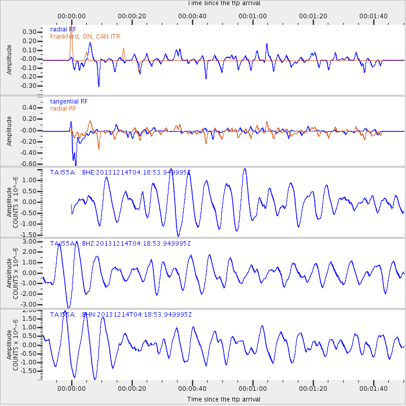
I55A Frankford, ON, CAN - Earthquake Result Viewer
*The percent match for this event was below the threshold and hence no stack was calculated.
| Earthquake location: |
Near East Coast Of Honshu, Japan |
| Earthquake latitude/longitude: |
35.7/140.7 |
| Earthquake time(UTC): |
2013/12/14 (348) 04:06:15 GMT |
| Earthquake Depth: |
42 km |
| Earthquake Magnitude: |
5.5 MWB, 5.6 MWC |
| Earthquake Catalog/Contributor: |
NEIC PDE/NEIC COMCAT |
|
| Network: |
TA USArray Transportable Network (new EarthScope stations) |
| Station: |
I55A Frankford, ON, CAN |
| Lat/Lon: |
44.22 N/77.68 W |
| Elevation: |
132 m |
|
| Distance: |
93.2 deg |
| Az: |
26.533 deg |
| Baz: |
329.606 deg |
| Ray Param: |
$rayparam |
*The percent match for this event was below the threshold and hence was not used in the summary stack. |
|
| Radial Match: |
75.77999 % |
| Radial Bump: |
400 |
| Transverse Match: |
86.54162 % |
| Transverse Bump: |
400 |
| SOD ConfigId: |
626651 |
| Insert Time: |
2014-04-20 00:52:57.070 +0000 |
| GWidth: |
2.5 |
| Max Bumps: |
400 |
| Tol: |
0.001 |
|
Signal To Noise
| Channel | StoN | STA | LTA |
| TA:I55A: :BHZ:20131214T04:18:53.949995Z | 2.5058384 | 2.0914808E-6 | 8.3464306E-7 |
| TA:I55A: :BHN:20131214T04:18:53.949995Z | 2.1838326 | 1.2082622E-6 | 5.53276E-7 |
| TA:I55A: :BHE:20131214T04:18:53.949995Z | 1.9331751 | 8.995637E-7 | 4.6532966E-7 |
| Arrivals |
| Ps | |
| PpPs | |
| PsPs/PpSs | |


