You are here: Home > Network List > TA - USArray Transportable Network (new EarthScope stations) Stations List
> Station O48A Farmland, IN, USA > Earthquake Result Viewer
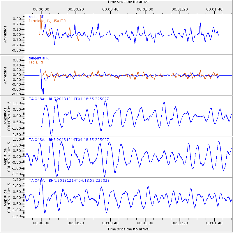
O48A Farmland, IN, USA - Earthquake Result Viewer
*The percent match for this event was below the threshold and hence no stack was calculated.
| Earthquake location: |
Near East Coast Of Honshu, Japan |
| Earthquake latitude/longitude: |
35.7/140.7 |
| Earthquake time(UTC): |
2013/12/14 (348) 04:06:15 GMT |
| Earthquake Depth: |
42 km |
| Earthquake Magnitude: |
5.5 MWB, 5.6 MWC |
| Earthquake Catalog/Contributor: |
NEIC PDE/NEIC COMCAT |
|
| Network: |
TA USArray Transportable Network (new EarthScope stations) |
| Station: |
O48A Farmland, IN, USA |
| Lat/Lon: |
40.26 N/85.16 W |
| Elevation: |
300 m |
|
| Distance: |
93.5 deg |
| Az: |
33.35 deg |
| Baz: |
324.195 deg |
| Ray Param: |
$rayparam |
*The percent match for this event was below the threshold and hence was not used in the summary stack. |
|
| Radial Match: |
55.846333 % |
| Radial Bump: |
400 |
| Transverse Match: |
90.99485 % |
| Transverse Bump: |
400 |
| SOD ConfigId: |
626651 |
| Insert Time: |
2014-04-20 00:54:55.685 +0000 |
| GWidth: |
2.5 |
| Max Bumps: |
400 |
| Tol: |
0.001 |
|
Signal To Noise
| Channel | StoN | STA | LTA |
| TA:O48A: :BHZ:20131214T04:18:55.22502Z | 1.4655093 | 7.893404E-7 | 5.3861163E-7 |
| TA:O48A: :BHN:20131214T04:18:55.22502Z | 3.7137194 | 9.0326046E-7 | 2.4322262E-7 |
| TA:O48A: :BHE:20131214T04:18:55.22502Z | 1.0910337 | 6.6386144E-7 | 6.084701E-7 |
| Arrivals |
| Ps | |
| PpPs | |
| PsPs/PpSs | |


