You are here: Home > Network List > TA - USArray Transportable Network (new EarthScope stations) Stations List
> Station O57A Amberson, PA, USA > Earthquake Result Viewer
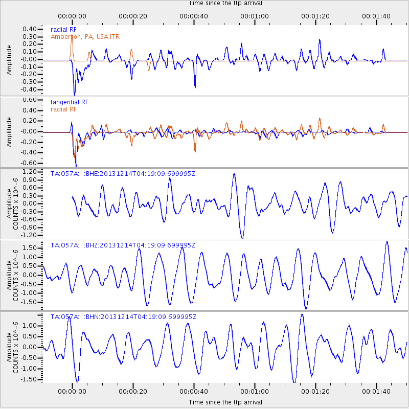
O57A Amberson, PA, USA - Earthquake Result Viewer
*The percent match for this event was below the threshold and hence no stack was calculated.
| Earthquake location: |
Near East Coast Of Honshu, Japan |
| Earthquake latitude/longitude: |
35.7/140.7 |
| Earthquake time(UTC): |
2013/12/14 (348) 04:06:15 GMT |
| Earthquake Depth: |
42 km |
| Earthquake Magnitude: |
5.5 MWB, 5.6 MWC |
| Earthquake Catalog/Contributor: |
NEIC PDE/NEIC COMCAT |
|
| Network: |
TA USArray Transportable Network (new EarthScope stations) |
| Station: |
O57A Amberson, PA, USA |
| Lat/Lon: |
40.21 N/77.64 W |
| Elevation: |
377 m |
|
| Distance: |
96.7 deg |
| Az: |
28.54 deg |
| Baz: |
329.464 deg |
| Ray Param: |
$rayparam |
*The percent match for this event was below the threshold and hence was not used in the summary stack. |
|
| Radial Match: |
66.34933 % |
| Radial Bump: |
400 |
| Transverse Match: |
86.90707 % |
| Transverse Bump: |
400 |
| SOD ConfigId: |
626651 |
| Insert Time: |
2014-04-20 00:55:06.026 +0000 |
| GWidth: |
2.5 |
| Max Bumps: |
400 |
| Tol: |
0.001 |
|
Signal To Noise
| Channel | StoN | STA | LTA |
| TA:O57A: :BHZ:20131214T04:19:09.699995Z | 0.7195205 | 5.024624E-7 | 6.983295E-7 |
| TA:O57A: :BHN:20131214T04:19:09.699995Z | 2.5999389 | 9.670314E-7 | 3.719439E-7 |
| TA:O57A: :BHE:20131214T04:19:09.699995Z | 1.700774 | 5.1583396E-7 | 3.0329366E-7 |
| Arrivals |
| Ps | |
| PpPs | |
| PsPs/PpSs | |


