You are here: Home > Network List > TA - USArray Transportable Network (new EarthScope stations) Stations List
> Station V49A McMinnville, TN, USA > Earthquake Result Viewer
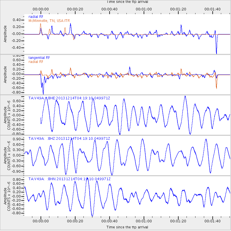
V49A McMinnville, TN, USA - Earthquake Result Viewer
*The percent match for this event was below the threshold and hence no stack was calculated.
| Earthquake location: |
Near East Coast Of Honshu, Japan |
| Earthquake latitude/longitude: |
35.7/140.7 |
| Earthquake time(UTC): |
2013/12/14 (348) 04:06:15 GMT |
| Earthquake Depth: |
42 km |
| Earthquake Magnitude: |
5.5 MWB, 5.6 MWC |
| Earthquake Catalog/Contributor: |
NEIC PDE/NEIC COMCAT |
|
| Network: |
TA USArray Transportable Network (new EarthScope stations) |
| Station: |
V49A McMinnville, TN, USA |
| Lat/Lon: |
35.77 N/85.90 W |
| Elevation: |
329 m |
|
| Distance: |
96.8 deg |
| Az: |
36.486 deg |
| Baz: |
323.455 deg |
| Ray Param: |
$rayparam |
*The percent match for this event was below the threshold and hence was not used in the summary stack. |
|
| Radial Match: |
34.39756 % |
| Radial Bump: |
400 |
| Transverse Match: |
84.69667 % |
| Transverse Bump: |
400 |
| SOD ConfigId: |
626651 |
| Insert Time: |
2014-04-20 00:56:37.484 +0000 |
| GWidth: |
2.5 |
| Max Bumps: |
400 |
| Tol: |
0.001 |
|
Signal To Noise
| Channel | StoN | STA | LTA |
| TA:V49A: :BHZ:20131214T04:19:10.049971Z | 1.385585 | 3.4361344E-7 | 2.479916E-7 |
| TA:V49A: :BHN:20131214T04:19:10.049971Z | 1.1131103 | 3.140268E-7 | 2.8211653E-7 |
| TA:V49A: :BHE:20131214T04:19:10.049971Z | 1.0123649 | 4.1979533E-7 | 4.1466802E-7 |
| Arrivals |
| Ps | |
| PpPs | |
| PsPs/PpSs | |


