You are here: Home > Network List > IU - Global Seismograph Network (GSN - IRIS/USGS) Stations List
> Station PMG Port Moresby, New Guinea > Earthquake Result Viewer
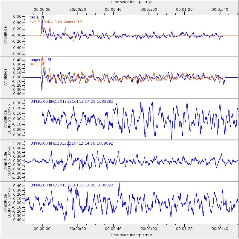
PMG Port Moresby, New Guinea - Earthquake Result Viewer
*The percent match for this event was below the threshold and hence no stack was calculated.
| Earthquake location: |
Off W. Coast Of S. Island, N.Z. |
| Earthquake latitude/longitude: |
-46.1/166.0 |
| Earthquake time(UTC): |
2013/12/16 (350) 12:07:24 GMT |
| Earthquake Depth: |
11 km |
| Earthquake Magnitude: |
5.8 MWW, 5.6 MWB, 5.7 MWC |
| Earthquake Catalog/Contributor: |
NEIC PDE/NEIC COMCAT |
|
| Network: |
IU Global Seismograph Network (GSN - IRIS/USGS) |
| Station: |
PMG Port Moresby, New Guinea |
| Lat/Lon: |
9.40 S/147.16 E |
| Elevation: |
90 m |
|
| Distance: |
40.0 deg |
| Az: |
330.267 deg |
| Baz: |
159.522 deg |
| Ray Param: |
$rayparam |
*The percent match for this event was below the threshold and hence was not used in the summary stack. |
|
| Radial Match: |
69.10335 % |
| Radial Bump: |
400 |
| Transverse Match: |
66.13178 % |
| Transverse Bump: |
400 |
| SOD ConfigId: |
626651 |
| Insert Time: |
2014-04-20 01:06:55.796 +0000 |
| GWidth: |
2.5 |
| Max Bumps: |
400 |
| Tol: |
0.001 |
|
Signal To Noise
| Channel | StoN | STA | LTA |
| IU:PMG:00:BHZ:20131216T12:14:28.168989Z | 2.0891852 | 1.3885634E-7 | 6.6464345E-8 |
| IU:PMG:00:BH1:20131216T12:14:28.168989Z | 1.1842989 | 1.0137354E-7 | 8.559794E-8 |
| IU:PMG:00:BH2:20131216T12:14:28.168989Z | 1.0163044 | 8.853539E-8 | 8.711503E-8 |
| Arrivals |
| Ps | |
| PpPs | |
| PsPs/PpSs | |


