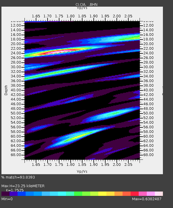
CIA Catalina Island Airport, California, USA - Earthquake Result Viewer
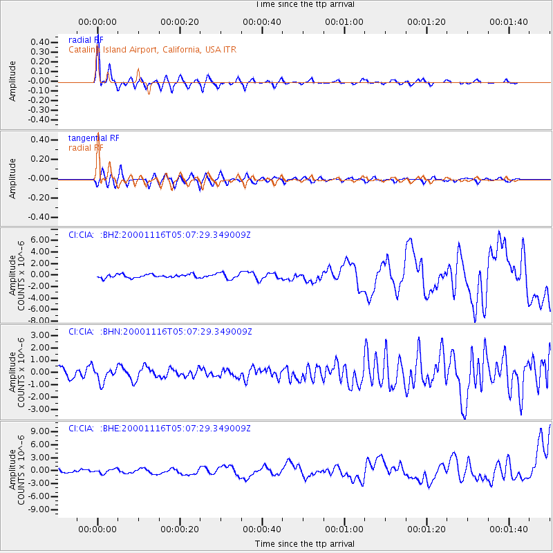
Earthquake location: New Ireland Region, P.N.G.
Earthquake latitude/longitude: -4.0/152.2
Earthquake time(UTC): 2000/11/16 (321) 04:54:56 GMT
Earthquake Depth: 33 km
Earthquake Magnitude: 6.0 MB, 8.2 MS, 8.0 MW, 8.0 ME
Earthquake Catalog/Contributor: WHDF/NEIC
Network: CI Caltech Regional Seismic Network
Station: CIA Catalina Island Airport, California, USA
Lat/Lon: 33.40 N/118.42 W
Elevation: 428 m
Distance: 91.7 deg
Az: 56.808 deg
Baz: 266.372 deg
Ray Param: 0.04156507
Estimated Moho Depth: 23.25 km
Estimated Crust Vp/Vs: 1.75
Assumed Crust Vp: 6.048 km/s
Estimated Crust Vs: 3.451 km/s
Estimated Crust Poisson's Ratio: 0.26
Radial Match: 93.8393 %
Radial Bump: 392
Transverse Match: 73.81333 %
Transverse Bump: 400
SOD ConfigId: 3744
Insert Time: 2010-02-25 20:54:38.580 +0000
GWidth: 2.5
Max Bumps: 400
Tol: 0.001

Signal To Noise

ChannelStoNSTALTA
CI:CIA: :BHN:20001116T05:07:29.349009Z1.78595965.5811466E-73.125013E-7
CI:CIA: :BHE:20001116T05:07:29.349009Z1.77262265.1339555E-72.8962484E-7
CI:CIA: :BHZ:20001116T05:07:29.349009Z1.84173545.452666E-72.960613E-7
Arrivals
Ps2.9 SECOND
PpPs10 SECOND
PsPs/PpSs13 SECOND