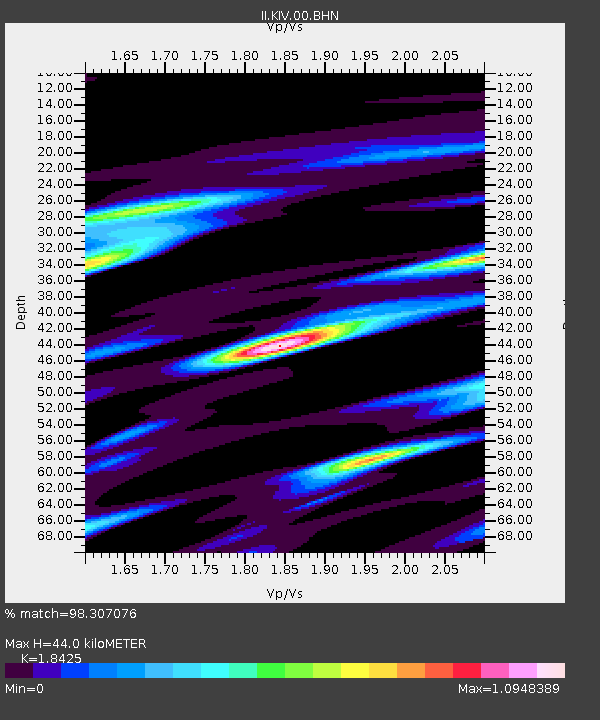
KIV Kislovodsk, Russia - Earthquake Result Viewer
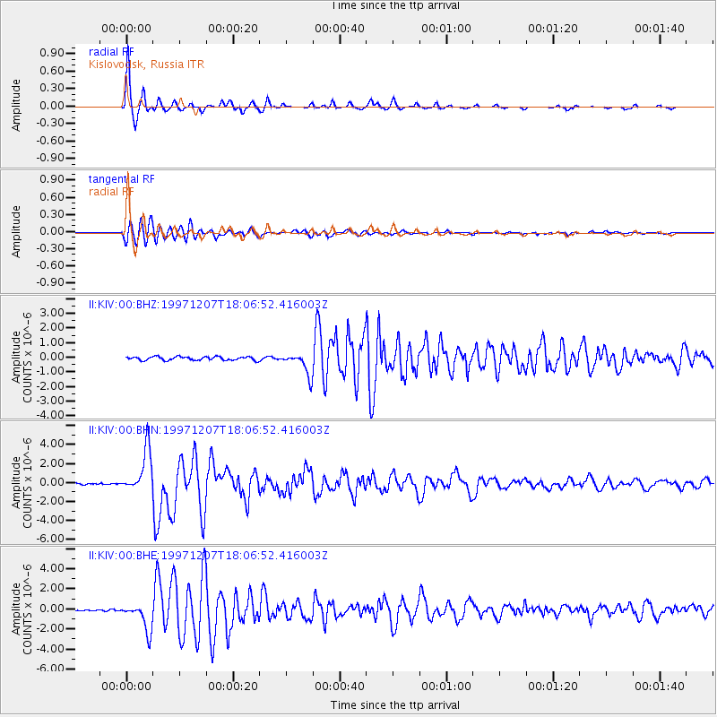
Earthquake location: Near East Coast Of Kamchatka
Earthquake latitude/longitude: 54.7/162.9
Earthquake time(UTC): 1997/12/07 (341) 17:56:18 GMT
Earthquake Depth: 33 km
Earthquake Magnitude: 5.6 MB, 6.0 MS, 6.3 UNKNOWN, 6.1 MW
Earthquake Catalog/Contributor: WHDF/NEIC
Network: II Global Seismograph Network (GSN - IRIS/IDA)
Station: KIV Kislovodsk, Russia
Lat/Lon: 43.96 N/42.69 E
Elevation: 1054 m
Distance: 69.4 deg
Az: 318.175 deg
Baz: 32.447 deg
Ray Param: 0.055623606
Estimated Moho Depth: 44.0 km
Estimated Crust Vp/Vs: 1.84
Assumed Crust Vp: 6.247 km/s
Estimated Crust Vs: 3.39 km/s
Estimated Crust Poisson's Ratio: 0.29
Radial Match: 98.307076 %
Radial Bump: 226
Transverse Match: 85.02064 %
Transverse Bump: 400
SOD ConfigId: 4480
Insert Time: 2010-03-01 18:13:23.788 +0000
GWidth: 2.5
Max Bumps: 400
Tol: 0.001

Signal To Noise

ChannelStoNSTALTA
II:KIV:00:BHN:19971207T18:06:52.416003Z33.3286482.2970426E-66.892096E-8
II:KIV:00:BHE:19971207T18:06:52.416003Z19.7063711.3962785E-67.085417E-8
II:KIV:00:BHZ:19971207T18:06:52.416003Z6.07446537.683755E-71.2649271E-7
Arrivals
Ps6.1 SECOND
PpPs19 SECOND
PsPs/PpSs25 SECOND