You are here: Home > Network List > TA - USArray Transportable Network (new EarthScope stations) Stations List
> Station MDND Maddock, ND, USA > Earthquake Result Viewer
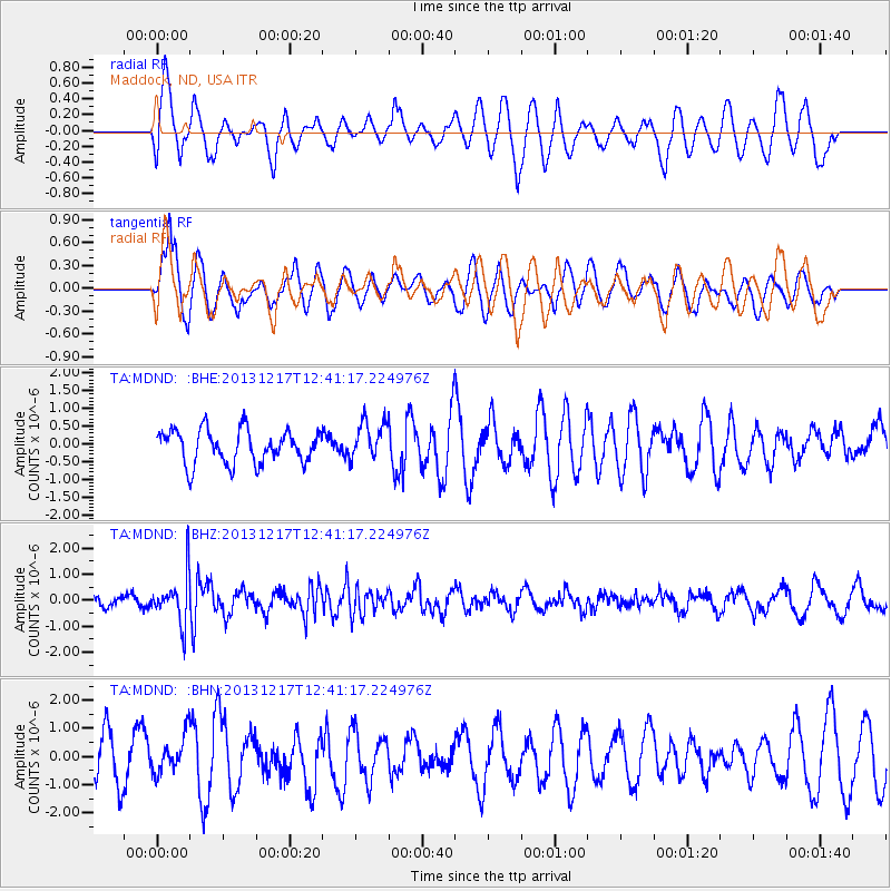
MDND Maddock, ND, USA - Earthquake Result Viewer
*The percent match for this event was below the threshold and hence no stack was calculated.
| Earthquake location: |
Near Coast Of Northern Chile |
| Earthquake latitude/longitude: |
-25.5/-70.5 |
| Earthquake time(UTC): |
2013/12/17 (351) 12:30:00 GMT |
| Earthquake Depth: |
72 km |
| Earthquake Magnitude: |
5.5 MWW, 5.4 MWR, 5.5 MWC, 5.6 MWB |
| Earthquake Catalog/Contributor: |
NEIC PDE/NEIC COMCAT |
|
| Network: |
TA USArray Transportable Network (new EarthScope stations) |
| Station: |
MDND Maddock, ND, USA |
| Lat/Lon: |
47.85 N/99.60 W |
| Elevation: |
479 m |
|
| Distance: |
77.6 deg |
| Az: |
340.411 deg |
| Baz: |
153.271 deg |
| Ray Param: |
$rayparam |
*The percent match for this event was below the threshold and hence was not used in the summary stack. |
|
| Radial Match: |
49.07295 % |
| Radial Bump: |
400 |
| Transverse Match: |
68.25158 % |
| Transverse Bump: |
400 |
| SOD ConfigId: |
626651 |
| Insert Time: |
2014-04-20 01:24:33.661 +0000 |
| GWidth: |
2.5 |
| Max Bumps: |
400 |
| Tol: |
0.001 |
|
Signal To Noise
| Channel | StoN | STA | LTA |
| TA:MDND: :BHZ:20131217T12:41:17.224976Z | 2.6867795 | 9.3731325E-7 | 3.4886125E-7 |
| TA:MDND: :BHN:20131217T12:41:17.224976Z | 0.66111827 | 6.7293763E-7 | 1.0178778E-6 |
| TA:MDND: :BHE:20131217T12:41:17.224976Z | 1.1503782 | 5.45124E-7 | 4.7386504E-7 |
| Arrivals |
| Ps | |
| PpPs | |
| PsPs/PpSs | |


