You are here: Home > Network List > TA - USArray Transportable Network (new EarthScope stations) Stations List
> Station P50A Jamestown, OH, USA > Earthquake Result Viewer
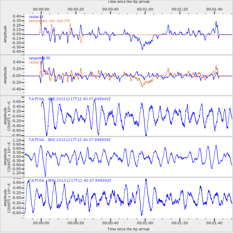
P50A Jamestown, OH, USA - Earthquake Result Viewer
*The percent match for this event was below the threshold and hence no stack was calculated.
| Earthquake location: |
Near Coast Of Northern Chile |
| Earthquake latitude/longitude: |
-25.5/-70.5 |
| Earthquake time(UTC): |
2013/12/17 (351) 12:30:00 GMT |
| Earthquake Depth: |
72 km |
| Earthquake Magnitude: |
5.5 MWW, 5.4 MWR, 5.5 MWC, 5.6 MWB |
| Earthquake Catalog/Contributor: |
NEIC PDE/NEIC COMCAT |
|
| Network: |
TA USArray Transportable Network (new EarthScope stations) |
| Station: |
P50A Jamestown, OH, USA |
| Lat/Lon: |
39.61 N/83.80 W |
| Elevation: |
318 m |
|
| Distance: |
66.0 deg |
| Az: |
348.797 deg |
| Baz: |
166.864 deg |
| Ray Param: |
$rayparam |
*The percent match for this event was below the threshold and hence was not used in the summary stack. |
|
| Radial Match: |
58.375305 % |
| Radial Bump: |
400 |
| Transverse Match: |
69.90756 % |
| Transverse Bump: |
400 |
| SOD ConfigId: |
626651 |
| Insert Time: |
2014-04-20 01:25:18.647 +0000 |
| GWidth: |
2.5 |
| Max Bumps: |
400 |
| Tol: |
0.001 |
|
Signal To Noise
| Channel | StoN | STA | LTA |
| TA:P50A: :BHZ:20131217T12:40:07.848999Z | 2.9401343 | 6.4398097E-7 | 2.1903114E-7 |
| TA:P50A: :BHN:20131217T12:40:07.848999Z | 0.8851682 | 2.8255226E-7 | 3.1920743E-7 |
| TA:P50A: :BHE:20131217T12:40:07.848999Z | 1.388268 | 4.7317366E-7 | 3.4083743E-7 |
| Arrivals |
| Ps | |
| PpPs | |
| PsPs/PpSs | |


