You are here: Home > Network List > TA - USArray Transportable Network (new EarthScope stations) Stations List
> Station P51A Williamsport, OH, USA > Earthquake Result Viewer
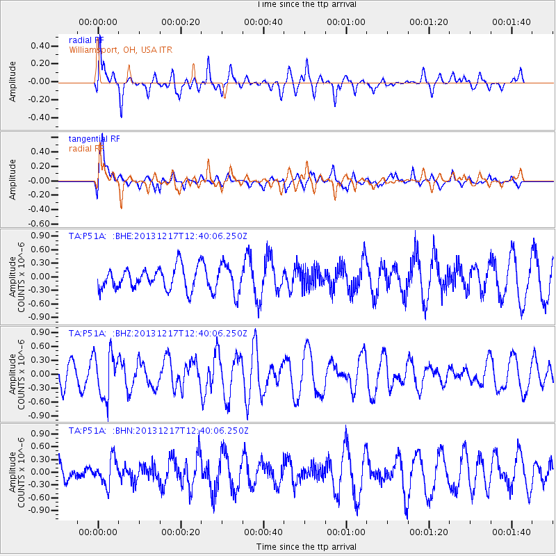
P51A Williamsport, OH, USA - Earthquake Result Viewer
*The percent match for this event was below the threshold and hence no stack was calculated.
| Earthquake location: |
Near Coast Of Northern Chile |
| Earthquake latitude/longitude: |
-25.5/-70.5 |
| Earthquake time(UTC): |
2013/12/17 (351) 12:30:00 GMT |
| Earthquake Depth: |
72 km |
| Earthquake Magnitude: |
5.5 MWW, 5.4 MWR, 5.5 MWC, 5.6 MWB |
| Earthquake Catalog/Contributor: |
NEIC PDE/NEIC COMCAT |
|
| Network: |
TA USArray Transportable Network (new EarthScope stations) |
| Station: |
P51A Williamsport, OH, USA |
| Lat/Lon: |
39.48 N/83.06 W |
| Elevation: |
211 m |
|
| Distance: |
65.7 deg |
| Az: |
349.377 deg |
| Baz: |
167.57 deg |
| Ray Param: |
$rayparam |
*The percent match for this event was below the threshold and hence was not used in the summary stack. |
|
| Radial Match: |
61.520473 % |
| Radial Bump: |
400 |
| Transverse Match: |
70.18888 % |
| Transverse Bump: |
400 |
| SOD ConfigId: |
626651 |
| Insert Time: |
2014-04-20 01:25:20.247 +0000 |
| GWidth: |
2.5 |
| Max Bumps: |
400 |
| Tol: |
0.001 |
|
Signal To Noise
| Channel | StoN | STA | LTA |
| TA:P51A: :BHZ:20131217T12:40:06.250Z | 2.1466484 | 4.838442E-7 | 2.2539517E-7 |
| TA:P51A: :BHN:20131217T12:40:06.250Z | 1.4597625 | 3.2328657E-7 | 2.214652E-7 |
| TA:P51A: :BHE:20131217T12:40:06.250Z | 1.3851271 | 3.3048138E-7 | 2.3859283E-7 |
| Arrivals |
| Ps | |
| PpPs | |
| PsPs/PpSs | |


