You are here: Home > Network List > TA - USArray Transportable Network (new EarthScope stations) Stations List
> Station Z41A Richland Creek Farm, El Dorado, AR, USA > Earthquake Result Viewer
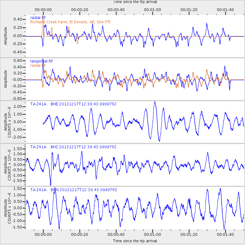
Z41A Richland Creek Farm, El Dorado, AR, USA - Earthquake Result Viewer
*The percent match for this event was below the threshold and hence no stack was calculated.
| Earthquake location: |
Near Coast Of Northern Chile |
| Earthquake latitude/longitude: |
-25.5/-70.5 |
| Earthquake time(UTC): |
2013/12/17 (351) 12:30:00 GMT |
| Earthquake Depth: |
72 km |
| Earthquake Magnitude: |
5.5 MWW, 5.4 MWR, 5.5 MWC, 5.6 MWB |
| Earthquake Catalog/Contributor: |
NEIC PDE/NEIC COMCAT |
|
| Network: |
TA USArray Transportable Network (new EarthScope stations) |
| Station: |
Z41A Richland Creek Farm, El Dorado, AR, USA |
| Lat/Lon: |
33.26 N/92.80 W |
| Elevation: |
62 m |
|
| Distance: |
62.2 deg |
| Az: |
338.946 deg |
| Baz: |
157.205 deg |
| Ray Param: |
$rayparam |
*The percent match for this event was below the threshold and hence was not used in the summary stack. |
|
| Radial Match: |
36.460556 % |
| Radial Bump: |
362 |
| Transverse Match: |
52.27058 % |
| Transverse Bump: |
364 |
| SOD ConfigId: |
626651 |
| Insert Time: |
2014-04-20 01:28:07.394 +0000 |
| GWidth: |
2.5 |
| Max Bumps: |
400 |
| Tol: |
0.001 |
|
Signal To Noise
| Channel | StoN | STA | LTA |
| TA:Z41A: :BHZ:20131217T12:39:43.099976Z | 1.9266181 | 6.836207E-7 | 3.5482938E-7 |
| TA:Z41A: :BHN:20131217T12:39:43.099976Z | 1.8946362 | 6.182597E-7 | 3.2632107E-7 |
| TA:Z41A: :BHE:20131217T12:39:43.099976Z | 1.0124352 | 6.756558E-7 | 6.673571E-7 |
| Arrivals |
| Ps | |
| PpPs | |
| PsPs/PpSs | |


