You are here: Home > Network List > CN - Canadian National Seismograph Network Stations List
> Station INK INUVIK, NT > Earthquake Result Viewer
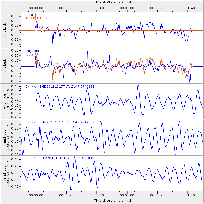
INK INUVIK, NT - Earthquake Result Viewer
*The percent match for this event was below the threshold and hence no stack was calculated.
| Earthquake location: |
Fiji Islands Region |
| Earthquake latitude/longitude: |
-20.7/-178.7 |
| Earthquake time(UTC): |
2013/12/17 (351) 17:02:01 GMT |
| Earthquake Depth: |
602 km |
| Earthquake Magnitude: |
5.7 MWB, 5.7 MWC |
| Earthquake Catalog/Contributor: |
NEIC PDE/NEIC COMCAT |
|
| Network: |
CN Canadian National Seismograph Network |
| Station: |
INK INUVIK, NT |
| Lat/Lon: |
68.31 N/133.53 W |
| Elevation: |
44 m |
|
| Distance: |
94.6 deg |
| Az: |
15.33 deg |
| Baz: |
221.737 deg |
| Ray Param: |
$rayparam |
*The percent match for this event was below the threshold and hence was not used in the summary stack. |
|
| Radial Match: |
42.551517 % |
| Radial Bump: |
400 |
| Transverse Match: |
58.428066 % |
| Transverse Bump: |
400 |
| SOD ConfigId: |
626651 |
| Insert Time: |
2014-04-20 01:38:37.859 +0000 |
| GWidth: |
2.5 |
| Max Bumps: |
400 |
| Tol: |
0.001 |
|
Signal To Noise
| Channel | StoN | STA | LTA |
| CN:INK: :BHZ:20131217T17:13:47.974988Z | 0.7539897 | 1.4782889E-7 | 1.960622E-7 |
| CN:INK: :BHN:20131217T17:13:47.974988Z | 0.7590867 | 1.0218564E-7 | 1.3461654E-7 |
| CN:INK: :BHE:20131217T17:13:47.974988Z | 1.9806068 | 2.3617528E-7 | 1.1924391E-7 |
| Arrivals |
| Ps | |
| PpPs | |
| PsPs/PpSs | |


