You are here: Home > Network List > II - Global Seismograph Network (GSN - IRIS/IDA) Stations List
> Station KAPI Kappang, Sulawesi, Indonesia > Earthquake Result Viewer
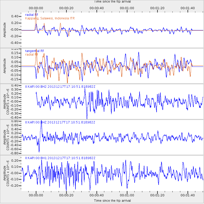
KAPI Kappang, Sulawesi, Indonesia - Earthquake Result Viewer
*The percent match for this event was below the threshold and hence no stack was calculated.
| Earthquake location: |
Fiji Islands Region |
| Earthquake latitude/longitude: |
-20.7/-178.7 |
| Earthquake time(UTC): |
2013/12/17 (351) 17:02:01 GMT |
| Earthquake Depth: |
602 km |
| Earthquake Magnitude: |
5.7 MWB, 5.7 MWC |
| Earthquake Catalog/Contributor: |
NEIC PDE/NEIC COMCAT |
|
| Network: |
II Global Seismograph Network (GSN - IRIS/IDA) |
| Station: |
KAPI Kappang, Sulawesi, Indonesia |
| Lat/Lon: |
5.01 S/119.75 E |
| Elevation: |
300 m |
|
| Distance: |
61.7 deg |
| Az: |
275.563 deg |
| Baz: |
110.723 deg |
| Ray Param: |
$rayparam |
*The percent match for this event was below the threshold and hence was not used in the summary stack. |
|
| Radial Match: |
53.531174 % |
| Radial Bump: |
400 |
| Transverse Match: |
51.6198 % |
| Transverse Bump: |
400 |
| SOD ConfigId: |
626651 |
| Insert Time: |
2014-04-20 01:40:03.413 +0000 |
| GWidth: |
2.5 |
| Max Bumps: |
400 |
| Tol: |
0.001 |
|
Signal To Noise
| Channel | StoN | STA | LTA |
| II:KAPI:00:BHZ:20131217T17:10:51.818982Z | 3.6052012 | 3.5128917E-7 | 9.743954E-8 |
| II:KAPI:00:BH1:20131217T17:10:51.818982Z | 1.2873055 | 9.016381E-8 | 7.004072E-8 |
| II:KAPI:00:BH2:20131217T17:10:51.818982Z | 1.9700989 | 1.5382308E-7 | 7.807887E-8 |
| Arrivals |
| Ps | |
| PpPs | |
| PsPs/PpSs | |


