You are here: Home > Network List > TA - USArray Transportable Network (new EarthScope stations) Stations List
> Station J05D Fort Rock, OR, USA > Earthquake Result Viewer
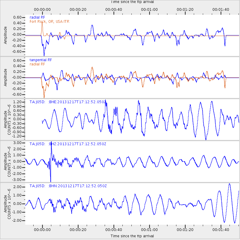
J05D Fort Rock, OR, USA - Earthquake Result Viewer
*The percent match for this event was below the threshold and hence no stack was calculated.
| Earthquake location: |
Fiji Islands Region |
| Earthquake latitude/longitude: |
-20.7/-178.7 |
| Earthquake time(UTC): |
2013/12/17 (351) 17:02:01 GMT |
| Earthquake Depth: |
602 km |
| Earthquake Magnitude: |
5.7 MWB, 5.7 MWC |
| Earthquake Catalog/Contributor: |
NEIC PDE/NEIC COMCAT |
|
| Network: |
TA USArray Transportable Network (new EarthScope stations) |
| Station: |
J05D Fort Rock, OR, USA |
| Lat/Lon: |
43.28 N/121.23 W |
| Elevation: |
1541 m |
|
| Distance: |
82.7 deg |
| Az: |
38.351 deg |
| Baz: |
232.698 deg |
| Ray Param: |
$rayparam |
*The percent match for this event was below the threshold and hence was not used in the summary stack. |
|
| Radial Match: |
64.7307 % |
| Radial Bump: |
400 |
| Transverse Match: |
59.34214 % |
| Transverse Bump: |
400 |
| SOD ConfigId: |
626651 |
| Insert Time: |
2014-04-20 01:44:04.833 +0000 |
| GWidth: |
2.5 |
| Max Bumps: |
400 |
| Tol: |
0.001 |
|
Signal To Noise
| Channel | StoN | STA | LTA |
| TA:J05D: :BHZ:20131217T17:12:52.050Z | 2.5718033 | 7.808739E-7 | 3.0362895E-7 |
| TA:J05D: :BHN:20131217T17:12:52.050Z | 1.0280912 | 3.8526105E-7 | 3.7473433E-7 |
| TA:J05D: :BHE:20131217T17:12:52.050Z | 1.0802492 | 4.7241784E-7 | 4.3732302E-7 |
| Arrivals |
| Ps | |
| PpPs | |
| PsPs/PpSs | |


