You are here: Home > Network List > AZ - ANZA Regional Network Stations List
> Station SMER AZ.SMER > Earthquake Result Viewer
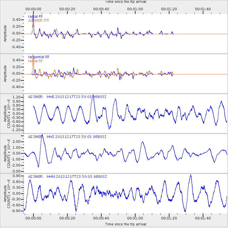
SMER AZ.SMER - Earthquake Result Viewer
*The percent match for this event was below the threshold and hence no stack was calculated.
| Earthquake location: |
Mariana Islands Region |
| Earthquake latitude/longitude: |
20.8/146.8 |
| Earthquake time(UTC): |
2013/12/17 (351) 23:38:06 GMT |
| Earthquake Depth: |
9.0 km |
| Earthquake Magnitude: |
6.2 MWW, 6.1 MWB, 6.2 MWC, 6.4 MWC |
| Earthquake Catalog/Contributor: |
NEIC PDE/NEIC COMCAT |
|
| Network: |
AZ ANZA Regional Network |
| Station: |
SMER AZ.SMER |
| Lat/Lon: |
33.46 N/117.17 W |
| Elevation: |
355 m |
|
| Distance: |
83.6 deg |
| Az: |
56.776 deg |
| Baz: |
290.546 deg |
| Ray Param: |
$rayparam |
*The percent match for this event was below the threshold and hence was not used in the summary stack. |
|
| Radial Match: |
70.984764 % |
| Radial Bump: |
336 |
| Transverse Match: |
49.960922 % |
| Transverse Bump: |
254 |
| SOD ConfigId: |
626651 |
| Insert Time: |
2014-04-20 01:54:20.840 +0000 |
| GWidth: |
2.5 |
| Max Bumps: |
400 |
| Tol: |
0.001 |
|
Signal To Noise
| Channel | StoN | STA | LTA |
| AZ:SMER: :HHZ:20131217T23:50:03.98803Z | 2.790001 | 1.1581591E-6 | 4.1511066E-7 |
| AZ:SMER: :HHN:20131217T23:50:03.98803Z | 0.60671955 | 2.757733E-7 | 4.5453177E-7 |
| AZ:SMER: :HHE:20131217T23:50:03.98803Z | 1.3691325 | 5.656206E-7 | 4.1312333E-7 |
| Arrivals |
| Ps | |
| PpPs | |
| PsPs/PpSs | |


