You are here: Home > Network List > G - GEOSCOPE Stations List
> Station NOUC Port Laguerre, New Caledonia > Earthquake Result Viewer
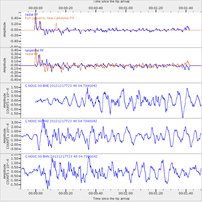
NOUC Port Laguerre, New Caledonia - Earthquake Result Viewer
*The percent match for this event was below the threshold and hence no stack was calculated.
| Earthquake location: |
Mariana Islands Region |
| Earthquake latitude/longitude: |
20.8/146.8 |
| Earthquake time(UTC): |
2013/12/17 (351) 23:38:06 GMT |
| Earthquake Depth: |
9.0 km |
| Earthquake Magnitude: |
6.2 MWW, 6.1 MWB, 6.2 MWC, 6.4 MWC |
| Earthquake Catalog/Contributor: |
NEIC PDE/NEIC COMCAT |
|
| Network: |
G GEOSCOPE |
| Station: |
NOUC Port Laguerre, New Caledonia |
| Lat/Lon: |
22.10 S/166.30 E |
| Elevation: |
112 m |
|
| Distance: |
46.7 deg |
| Az: |
154.799 deg |
| Baz: |
334.555 deg |
| Ray Param: |
$rayparam |
*The percent match for this event was below the threshold and hence was not used in the summary stack. |
|
| Radial Match: |
78.27321 % |
| Radial Bump: |
400 |
| Transverse Match: |
58.791275 % |
| Transverse Bump: |
400 |
| SOD ConfigId: |
626651 |
| Insert Time: |
2014-04-20 01:58:04.129 +0000 |
| GWidth: |
2.5 |
| Max Bumps: |
400 |
| Tol: |
0.001 |
|
Signal To Noise
| Channel | StoN | STA | LTA |
| G:NOUC:00:BHZ:20131217T23:46:04.799004Z | 6.4414225 | 1.7688866E-6 | 2.7461118E-7 |
| G:NOUC:00:BHN:20131217T23:46:04.799004Z | 1.3075111 | 3.4436184E-7 | 2.6337202E-7 |
| G:NOUC:00:BHE:20131217T23:46:04.799004Z | 2.5600996 | 6.148072E-7 | 2.4014972E-7 |
| Arrivals |
| Ps | |
| PpPs | |
| PsPs/PpSs | |


