You are here: Home > Network List > IN - National Seismic Network of India Stations List
> Station SHL Shillong, Meghalaya, India > Earthquake Result Viewer
SHL Shillong, Meghalaya, India - Earthquake Result Viewer
| Earthquake location: |
Mariana Islands Region |
| Earthquake latitude/longitude: |
20.8/146.8 |
| Earthquake time(UTC): |
2013/12/17 (351) 23:38:06 GMT |
| Earthquake Depth: |
9.0 km |
| Earthquake Magnitude: |
6.2 MWW, 6.1 MWB, 6.2 MWC, 6.4 MWC |
| Earthquake Catalog/Contributor: |
NEIC PDE/NEIC COMCAT |
|
| Network: |
IN National Seismic Network of India |
| Station: |
SHL Shillong, Meghalaya, India |
| Lat/Lon: |
25.57 N/91.86 E |
| Elevation: |
2.0 m |
|
| Distance: |
50.4 deg |
| Az: |
286.479 deg |
| Baz: |
83.468 deg |
| Ray Param: |
0.068060175 |
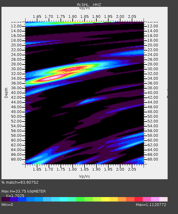
| Estimated Moho Depth: |
33.75 km |
| Estimated Crust Vp/Vs: |
1.70 |
| Assumed Crust Vp: |
6.273 km/s |
| Estimated Crust Vs: |
3.685 km/s |
| Estimated Crust Poisson's Ratio: |
0.24 |
|
| Radial Match: |
93.90752 % |
| Radial Bump: |
349 |
| Transverse Match: |
66.93175 % |
| Transverse Bump: |
400 |
| SOD ConfigId: |
626651 |
| Insert Time: |
2014-04-20 02:00:29.871 +0000 |
| GWidth: |
2.5 |
| Max Bumps: |
400 |
| Tol: |
0.001 |
|

Signal To Noise
| Channel | StoN | STA | LTA |
| IN:SHL: :HHZ:20131217T23:46:33.670006Z | 18.07601 | 1.7093093E-6 | 9.456232E-8 |
| IN:SHL: :HHN:20131217T23:46:33.670006Z | 1.1382484 | 1.9991617E-7 | 1.7563492E-7 |
| IN:SHL: :HHE:20131217T23:46:33.670006Z | 7.502305 | 9.475787E-7 | 1.2630501E-7 |
| Arrivals |
| Ps | 4.0 SECOND |
| PpPs | 14 SECOND |
| PsPs/PpSs | 18 SECOND |


