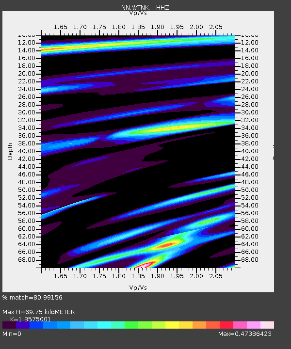
WTNK 7433 Soaring Heights w84gm - Earthquake Result Viewer

Earthquake location: Mariana Islands Region
Earthquake latitude/longitude: 20.8/146.8
Earthquake time(UTC): 2013/12/17 (351) 23:38:06 GMT
Earthquake Depth: 9.0 km
Earthquake Magnitude: 6.2 MWW, 6.1 MWB, 6.2 MWC, 6.4 MWC
Earthquake Catalog/Contributor: NEIC PDE/NEIC COMCAT
Network: NN Western Great Basin/Eastern Sierra Nevada
Station: WTNK 7433 Soaring Heights w84gm
Lat/Lon: 36.19 N/115.01 W
Elevation: 676 m
Distance: 84.3 deg
Az: 53.576 deg
Baz: 291.437 deg
Ray Param: 0.045583826
Estimated Moho Depth: 69.75 km
Estimated Crust Vp/Vs: 1.86
Assumed Crust Vp: 6.276 km/s
Estimated Crust Vs: 3.379 km/s
Estimated Crust Poisson's Ratio: 0.30
Radial Match: 80.99156 %
Radial Bump: 348
Transverse Match: 76.47397 %
Transverse Bump: 394
SOD ConfigId: 626651
Insert Time: 2014-04-20 02:04:17.490 +0000
GWidth: 2.5
Max Bumps: 400
Tol: 0.001

Signal To Noise

ChannelStoNSTALTA
NN:WTNK: :HHZ:20131217T23:50:07.445Z7.3787091.0914299E-61.4791613E-7
NN:WTNK: :HHN:20131217T23:50:07.445Z1.3413962.2117723E-71.6488586E-7
NN:WTNK: :HHE:20131217T23:50:07.445Z1.88827593.4160058E-71.8090607E-7
Arrivals
Ps9.7 SECOND
PpPs31 SECOND
PsPs/PpSs41 SECOND