You are here: Home > Network List > TA - USArray Transportable Network (new EarthScope stations) Stations List
> Station G03D McMinnville, OR, USA > Earthquake Result Viewer
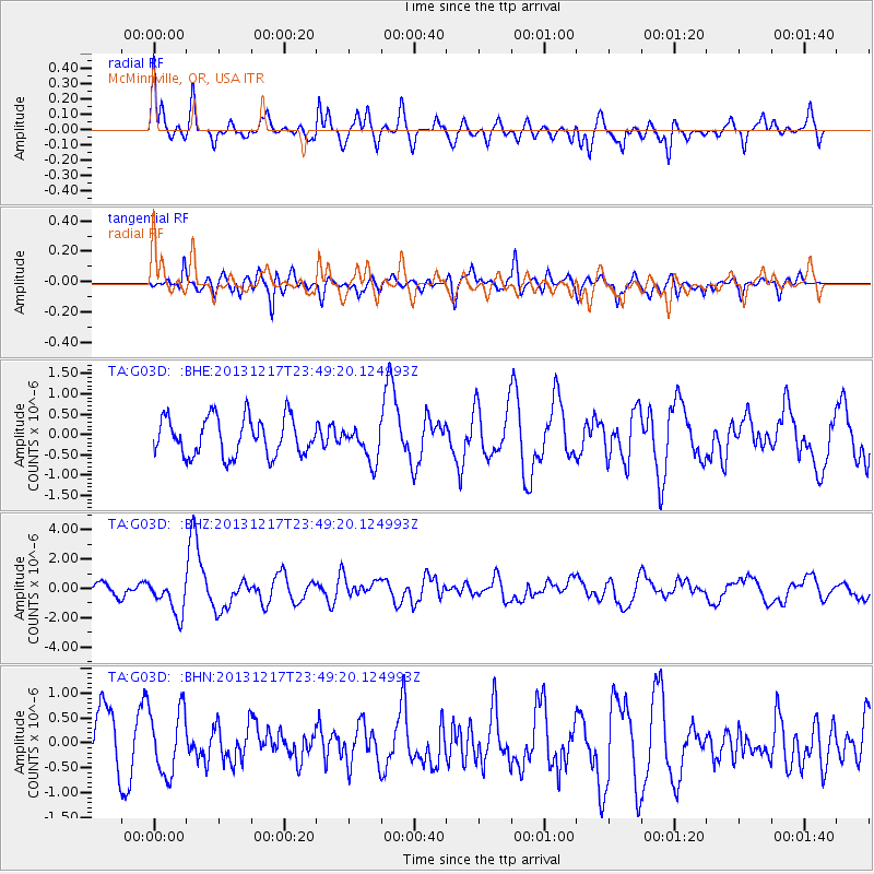
G03D McMinnville, OR, USA - Earthquake Result Viewer
*The percent match for this event was below the threshold and hence no stack was calculated.
| Earthquake location: |
Mariana Islands Region |
| Earthquake latitude/longitude: |
20.8/146.8 |
| Earthquake time(UTC): |
2013/12/17 (351) 23:38:06 GMT |
| Earthquake Depth: |
9.0 km |
| Earthquake Magnitude: |
6.2 MWW, 6.1 MWB, 6.2 MWC, 6.4 MWC |
| Earthquake Catalog/Contributor: |
NEIC PDE/NEIC COMCAT |
|
| Network: |
TA USArray Transportable Network (new EarthScope stations) |
| Station: |
G03D McMinnville, OR, USA |
| Lat/Lon: |
45.21 N/123.26 W |
| Elevation: |
222 m |
|
| Distance: |
75.5 deg |
| Az: |
46.891 deg |
| Baz: |
284.878 deg |
| Ray Param: |
$rayparam |
*The percent match for this event was below the threshold and hence was not used in the summary stack. |
|
| Radial Match: |
76.976 % |
| Radial Bump: |
400 |
| Transverse Match: |
64.431145 % |
| Transverse Bump: |
400 |
| SOD ConfigId: |
626651 |
| Insert Time: |
2014-04-20 02:07:43.661 +0000 |
| GWidth: |
2.5 |
| Max Bumps: |
400 |
| Tol: |
0.001 |
|
Signal To Noise
| Channel | StoN | STA | LTA |
| TA:G03D: :BHZ:20131217T23:49:20.124993Z | 3.0556283 | 1.1900023E-6 | 3.89446E-7 |
| TA:G03D: :BHN:20131217T23:49:20.124993Z | 1.1564615 | 6.5133617E-7 | 5.632147E-7 |
| TA:G03D: :BHE:20131217T23:49:20.124993Z | 0.91099703 | 4.2948722E-7 | 4.7144744E-7 |
| Arrivals |
| Ps | |
| PpPs | |
| PsPs/PpSs | |


