You are here: Home > Network List > TA - USArray Transportable Network (new EarthScope stations) Stations List
> Station MDND Maddock, ND, USA > Earthquake Result Viewer
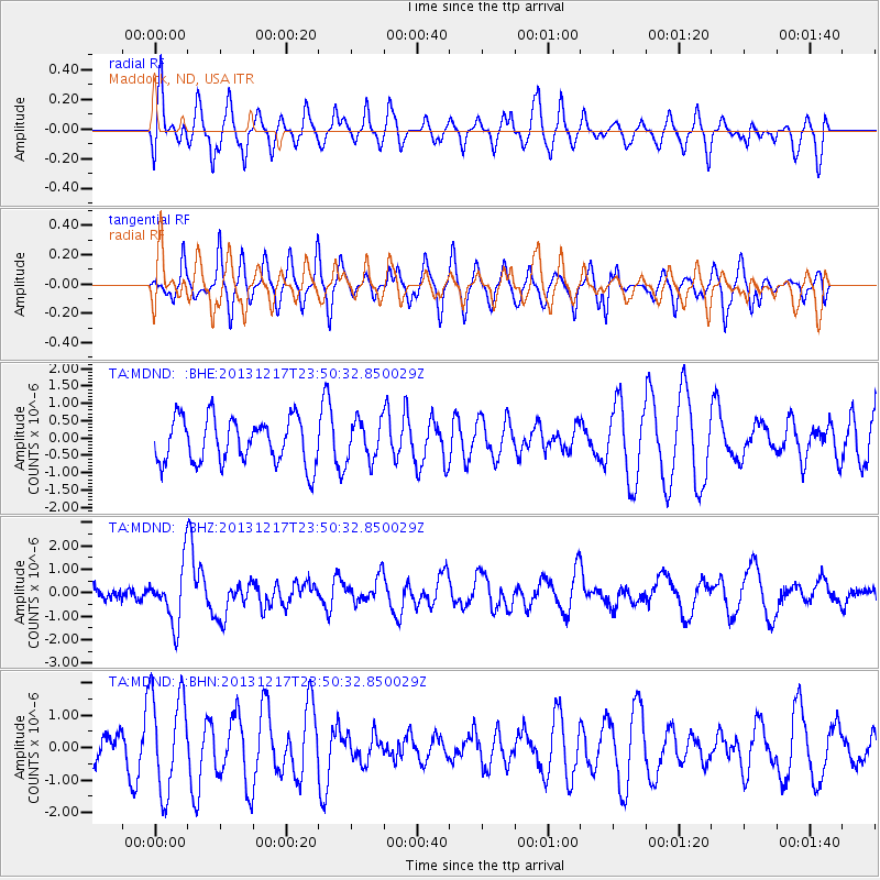
MDND Maddock, ND, USA - Earthquake Result Viewer
*The percent match for this event was below the threshold and hence no stack was calculated.
| Earthquake location: |
Mariana Islands Region |
| Earthquake latitude/longitude: |
20.8/146.8 |
| Earthquake time(UTC): |
2013/12/17 (351) 23:38:06 GMT |
| Earthquake Depth: |
9.0 km |
| Earthquake Magnitude: |
6.2 MWW, 6.1 MWB, 6.2 MWC, 6.4 MWC |
| Earthquake Catalog/Contributor: |
NEIC PDE/NEIC COMCAT |
|
| Network: |
TA USArray Transportable Network (new EarthScope stations) |
| Station: |
MDND Maddock, ND, USA |
| Lat/Lon: |
47.85 N/99.60 W |
| Elevation: |
479 m |
|
| Distance: |
89.5 deg |
| Az: |
38.114 deg |
| Baz: |
300.963 deg |
| Ray Param: |
$rayparam |
*The percent match for this event was below the threshold and hence was not used in the summary stack. |
|
| Radial Match: |
53.316944 % |
| Radial Bump: |
400 |
| Transverse Match: |
49.865654 % |
| Transverse Bump: |
379 |
| SOD ConfigId: |
626651 |
| Insert Time: |
2014-04-20 02:08:59.733 +0000 |
| GWidth: |
2.5 |
| Max Bumps: |
400 |
| Tol: |
0.001 |
|
Signal To Noise
| Channel | StoN | STA | LTA |
| TA:MDND: :BHZ:20131217T23:50:32.850029Z | 4.255795 | 1.2161345E-6 | 2.8575965E-7 |
| TA:MDND: :BHN:20131217T23:50:32.850029Z | 2.2519498 | 1.5336656E-6 | 6.81039E-7 |
| TA:MDND: :BHE:20131217T23:50:32.850029Z | 0.87109154 | 5.6673076E-7 | 6.505984E-7 |
| Arrivals |
| Ps | |
| PpPs | |
| PsPs/PpSs | |


