You are here: Home > Network List > US - United States National Seismic Network Stations List
> Station AGMN Agassiz National Wildlife Refuge, Minnesota, USA > Earthquake Result Viewer
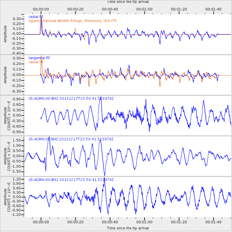
AGMN Agassiz National Wildlife Refuge, Minnesota, USA - Earthquake Result Viewer
*The percent match for this event was below the threshold and hence no stack was calculated.
| Earthquake location: |
Mariana Islands Region |
| Earthquake latitude/longitude: |
20.8/146.8 |
| Earthquake time(UTC): |
2013/12/17 (351) 23:38:06 GMT |
| Earthquake Depth: |
9.0 km |
| Earthquake Magnitude: |
6.2 MWW, 6.1 MWB, 6.2 MWC, 6.4 MWC |
| Earthquake Catalog/Contributor: |
NEIC PDE/NEIC COMCAT |
|
| Network: |
US United States National Seismic Network |
| Station: |
AGMN Agassiz National Wildlife Refuge, Minnesota, USA |
| Lat/Lon: |
48.30 N/95.86 W |
| Elevation: |
351 m |
|
| Distance: |
91.4 deg |
| Az: |
36.391 deg |
| Baz: |
303.753 deg |
| Ray Param: |
$rayparam |
*The percent match for this event was below the threshold and hence was not used in the summary stack. |
|
| Radial Match: |
53.686268 % |
| Radial Bump: |
400 |
| Transverse Match: |
80.09117 % |
| Transverse Bump: |
315 |
| SOD ConfigId: |
626651 |
| Insert Time: |
2014-04-20 02:10:08.572 +0000 |
| GWidth: |
2.5 |
| Max Bumps: |
400 |
| Tol: |
0.001 |
|
Signal To Noise
| Channel | StoN | STA | LTA |
| US:AGMN:00:BHZ:20131217T23:50:41.523979Z | 3.8590255 | 8.531402E-7 | 2.210766E-7 |
| US:AGMN:00:BH1:20131217T23:50:41.523979Z | 1.0599092 | 2.435351E-7 | 2.2976978E-7 |
| US:AGMN:00:BH2:20131217T23:50:41.523979Z | 2.454175 | 5.7955674E-7 | 2.3615137E-7 |
| Arrivals |
| Ps | |
| PpPs | |
| PsPs/PpSs | |


