You are here: Home > Network List > US - United States National Seismic Network Stations List
> Station DGMT Dagmar, Montana, USA > Earthquake Result Viewer
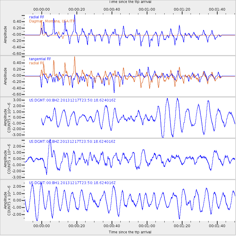
DGMT Dagmar, Montana, USA - Earthquake Result Viewer
*The percent match for this event was below the threshold and hence no stack was calculated.
| Earthquake location: |
Mariana Islands Region |
| Earthquake latitude/longitude: |
20.8/146.8 |
| Earthquake time(UTC): |
2013/12/17 (351) 23:38:06 GMT |
| Earthquake Depth: |
9.0 km |
| Earthquake Magnitude: |
6.2 MWW, 6.1 MWB, 6.2 MWC, 6.4 MWC |
| Earthquake Catalog/Contributor: |
NEIC PDE/NEIC COMCAT |
|
| Network: |
US United States National Seismic Network |
| Station: |
DGMT Dagmar, Montana, USA |
| Lat/Lon: |
48.47 N/104.20 W |
| Elevation: |
0.0 m |
|
| Distance: |
86.5 deg |
| Az: |
39.075 deg |
| Baz: |
297.584 deg |
| Ray Param: |
$rayparam |
*The percent match for this event was below the threshold and hence was not used in the summary stack. |
|
| Radial Match: |
73.79148 % |
| Radial Bump: |
297 |
| Transverse Match: |
47.562008 % |
| Transverse Bump: |
284 |
| SOD ConfigId: |
626651 |
| Insert Time: |
2014-04-20 02:10:28.307 +0000 |
| GWidth: |
2.5 |
| Max Bumps: |
400 |
| Tol: |
0.001 |
|
Signal To Noise
| Channel | StoN | STA | LTA |
| US:DGMT:00:BHZ:20131217T23:50:18.624016Z | 3.4204643 | 1.4533525E-6 | 4.2489918E-7 |
| US:DGMT:00:BH1:20131217T23:50:18.624016Z | 1.4141355 | 1.3356071E-6 | 9.44469E-7 |
| US:DGMT:00:BH2:20131217T23:50:18.624016Z | 1.2562633 | 1.0232612E-6 | 8.1452777E-7 |
| Arrivals |
| Ps | |
| PpPs | |
| PsPs/PpSs | |


