You are here: Home > Network List > UW - Pacific Northwest Regional Seismic Network Stations List
> Station PASS Maple Falls, WA, USA > Earthquake Result Viewer
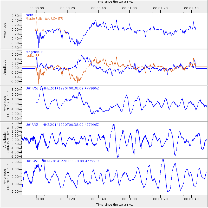
PASS Maple Falls, WA, USA - Earthquake Result Viewer
*The percent match for this event was below the threshold and hence no stack was calculated.
| Earthquake location: |
Philippine Islands Region |
| Earthquake latitude/longitude: |
11.6/126.3 |
| Earthquake time(UTC): |
2014/12/20 (354) 00:25:17 GMT |
| Earthquake Depth: |
2.0 km |
| Earthquake Magnitude: |
6.0 mb, 5.1 ML, 5.6 MS |
| Earthquake Catalog/Contributor: |
ISC/ISC |
|
| Network: |
UW Pacific Northwest Regional Seismic Network |
| Station: |
PASS Maple Falls, WA, USA |
| Lat/Lon: |
49.00 N/122.09 W |
| Elevation: |
174 m |
|
| Distance: |
95.0 deg |
| Az: |
37.92 deg |
| Baz: |
293.909 deg |
| Ray Param: |
$rayparam |
*The percent match for this event was below the threshold and hence was not used in the summary stack. |
|
| Radial Match: |
61.132637 % |
| Radial Bump: |
400 |
| Transverse Match: |
40.22826 % |
| Transverse Bump: |
400 |
| SOD ConfigId: |
3390531 |
| Insert Time: |
2019-04-15 16:40:28.779 +0000 |
| GWidth: |
2.5 |
| Max Bumps: |
400 |
| Tol: |
0.001 |
|
Signal To Noise
| Channel | StoN | STA | LTA |
| UW:PASS: :HHZ:20141220T00:38:09.477996Z | 0.68528605 | 5.7759394E-7 | 8.4285085E-7 |
| UW:PASS: :HHN:20141220T00:38:09.477996Z | 2.293907 | 1.7635382E-6 | 7.6879235E-7 |
| UW:PASS: :HHE:20141220T00:38:09.477996Z | 0.8258575 | 8.7623846E-7 | 1.0610044E-6 |
| Arrivals |
| Ps | |
| PpPs | |
| PsPs/PpSs | |


