You are here: Home > Network List > UU - University of Utah Regional Network Stations List
> Station CCUT Cedar City, UT, USA > Earthquake Result Viewer
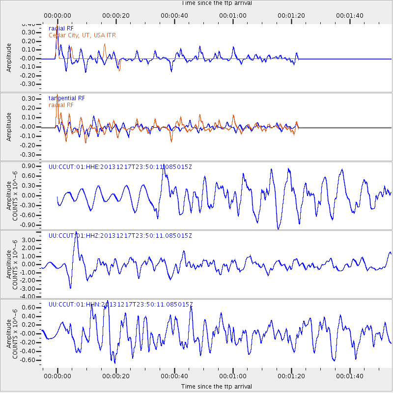
CCUT Cedar City, UT, USA - Earthquake Result Viewer
*The percent match for this event was below the threshold and hence no stack was calculated.
| Earthquake location: |
Mariana Islands Region |
| Earthquake latitude/longitude: |
20.8/146.8 |
| Earthquake time(UTC): |
2013/12/17 (351) 23:38:06 GMT |
| Earthquake Depth: |
9.0 km |
| Earthquake Magnitude: |
6.2 MWW, 6.1 MWB, 6.2 MWC, 6.4 MWC |
| Earthquake Catalog/Contributor: |
NEIC PDE/NEIC COMCAT |
|
| Network: |
UU University of Utah Regional Network |
| Station: |
CCUT Cedar City, UT, USA |
| Lat/Lon: |
37.55 N/113.36 W |
| Elevation: |
2127 m |
|
| Distance: |
85.0 deg |
| Az: |
51.817 deg |
| Baz: |
292.258 deg |
| Ray Param: |
$rayparam |
*The percent match for this event was below the threshold and hence was not used in the summary stack. |
|
| Radial Match: |
73.24823 % |
| Radial Bump: |
400 |
| Transverse Match: |
70.211655 % |
| Transverse Bump: |
400 |
| SOD ConfigId: |
626651 |
| Insert Time: |
2014-04-20 02:11:49.763 +0000 |
| GWidth: |
2.5 |
| Max Bumps: |
400 |
| Tol: |
0.001 |
|
Signal To Noise
| Channel | StoN | STA | LTA |
| UU:CCUT:01:HHZ:20131217T23:50:11.085015Z | 3.9594045 | 1.0569153E-6 | 2.6693795E-7 |
| UU:CCUT:01:HHN:20131217T23:50:11.085015Z | 1.4535576 | 1.7653447E-7 | 1.2144993E-7 |
| UU:CCUT:01:HHE:20131217T23:50:11.085015Z | 1.8230302 | 3.3249185E-7 | 1.8238416E-7 |
| Arrivals |
| Ps | |
| PpPs | |
| PsPs/PpSs | |


