You are here: Home > Network List > UU - University of Utah Regional Network Stations List
> Station PKCU Pink Cliffs, UT, USA > Earthquake Result Viewer
PKCU Pink Cliffs, UT, USA - Earthquake Result Viewer
| Earthquake location: |
Mariana Islands Region |
| Earthquake latitude/longitude: |
20.8/146.8 |
| Earthquake time(UTC): |
2013/12/17 (351) 23:38:06 GMT |
| Earthquake Depth: |
9.0 km |
| Earthquake Magnitude: |
6.2 MWW, 6.1 MWB, 6.2 MWC, 6.4 MWC |
| Earthquake Catalog/Contributor: |
NEIC PDE/NEIC COMCAT |
|
| Network: |
UU University of Utah Regional Network |
| Station: |
PKCU Pink Cliffs, UT, USA |
| Lat/Lon: |
37.44 N/112.31 W |
| Elevation: |
2834 m |
|
| Distance: |
85.8 deg |
| Az: |
51.594 deg |
| Baz: |
292.878 deg |
| Ray Param: |
0.044481788 |
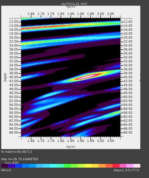
| Estimated Moho Depth: |
39.75 km |
| Estimated Crust Vp/Vs: |
1.92 |
| Assumed Crust Vp: |
6.194 km/s |
| Estimated Crust Vs: |
3.218 km/s |
| Estimated Crust Poisson's Ratio: |
0.32 |
|
| Radial Match: |
85.96713 % |
| Radial Bump: |
400 |
| Transverse Match: |
59.29091 % |
| Transverse Bump: |
356 |
| SOD ConfigId: |
626651 |
| Insert Time: |
2014-04-20 02:12:13.176 +0000 |
| GWidth: |
2.5 |
| Max Bumps: |
400 |
| Tol: |
0.001 |
|

Signal To Noise
| Channel | StoN | STA | LTA |
| UU:PKCU:01:HHZ:20131217T23:50:15.119988Z | 4.676203 | 3.5746655E-8 | 7.644377E-9 |
| UU:PKCU:01:HHN:20131217T23:50:15.119988Z | 1.5188272 | 2.1478408E-8 | 1.4141443E-8 |
| UU:PKCU:01:HHE:20131217T23:50:15.119988Z | 0.6793517 | 1.1514742E-8 | 1.6949604E-8 |
| Arrivals |
| Ps | 6.1 SECOND |
| PpPs | 18 SECOND |
| PsPs/PpSs | 24 SECOND |


