You are here: Home > Network List > UW - Pacific Northwest Regional Seismic Network Stations List
> Station STOR Enumclaw, WA, USA > Earthquake Result Viewer
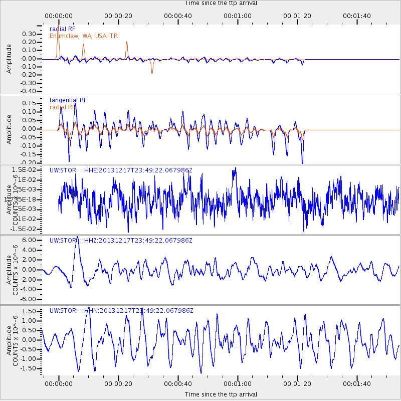
STOR Enumclaw, WA, USA - Earthquake Result Viewer
*The percent match for this event was below the threshold and hence no stack was calculated.
| Earthquake location: |
Mariana Islands Region |
| Earthquake latitude/longitude: |
20.8/146.8 |
| Earthquake time(UTC): |
2013/12/17 (351) 23:38:06 GMT |
| Earthquake Depth: |
9.0 km |
| Earthquake Magnitude: |
6.2 MWW, 6.1 MWB, 6.2 MWC, 6.4 MWC |
| Earthquake Catalog/Contributor: |
NEIC PDE/NEIC COMCAT |
|
| Network: |
UW Pacific Northwest Regional Seismic Network |
| Station: |
STOR Enumclaw, WA, USA |
| Lat/Lon: |
47.19 N/121.99 W |
| Elevation: |
266 m |
|
| Distance: |
75.9 deg |
| Az: |
44.683 deg |
| Baz: |
285.25 deg |
| Ray Param: |
$rayparam |
*The percent match for this event was below the threshold and hence was not used in the summary stack. |
|
| Radial Match: |
80.14719 % |
| Radial Bump: |
400 |
| Transverse Match: |
80.24268 % |
| Transverse Bump: |
400 |
| SOD ConfigId: |
626651 |
| Insert Time: |
2014-04-20 02:13:37.130 +0000 |
| GWidth: |
2.5 |
| Max Bumps: |
400 |
| Tol: |
0.001 |
|
Signal To Noise
| Channel | StoN | STA | LTA |
| UW:STOR: :HHZ:20131217T23:49:22.067986Z | 2.619688 | 1.601654E-6 | 6.1139116E-7 |
| UW:STOR: :HHN:20131217T23:49:22.067986Z | 1.2360172 | 3.3851572E-7 | 2.7387622E-7 |
| UW:STOR: :HHE:20131217T23:49:22.067986Z | 0.84700775 | 4.7641944E-9 | 5.624736E-9 |
| Arrivals |
| Ps | |
| PpPs | |
| PsPs/PpSs | |


