You are here: Home > Network List > WY - Yellowstone Wyoming Seismic Network Stations List
> Station YHH Holmes Hill, YNP, WY, USA > Earthquake Result Viewer
YHH Holmes Hill, YNP, WY, USA - Earthquake Result Viewer
*The percent match for this event was below the threshold and hence no stack was calculated.
| Earthquake location: |
Mariana Islands Region |
| Earthquake latitude/longitude: |
20.8/146.8 |
| Earthquake time(UTC): |
2013/12/17 (351) 23:38:06 GMT |
| Earthquake Depth: |
9.0 km |
| Earthquake Magnitude: |
6.2 MWW, 6.1 MWB, 6.2 MWC, 6.4 MWC |
| Earthquake Catalog/Contributor: |
NEIC PDE/NEIC COMCAT |
|
| Network: |
WY Yellowstone Wyoming Seismic Network |
| Station: |
YHH Holmes Hill, YNP, WY, USA |
| Lat/Lon: |
44.79 N/110.85 W |
| Elevation: |
2717 m |
|
| Distance: |
84.0 deg |
| Az: |
44.382 deg |
| Baz: |
293.195 deg |
| Ray Param: |
$rayparam |
*The percent match for this event was below the threshold and hence was not used in the summary stack. |
|
| Radial Match: |
77.057945 % |
| Radial Bump: |
340 |
| Transverse Match: |
71.93385 % |
| Transverse Bump: |
400 |
| SOD ConfigId: |
626651 |
| Insert Time: |
2014-04-20 02:13:55.419 +0000 |
| GWidth: |
2.5 |
| Max Bumps: |
400 |
| Tol: |
0.001 |
|
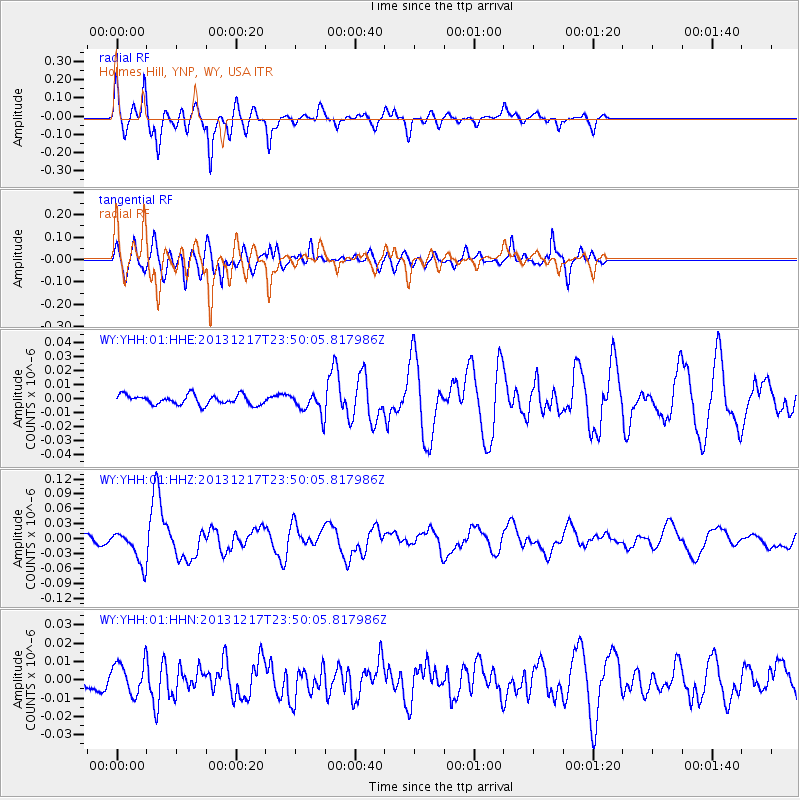
Signal To Noise
| Channel | StoN | STA | LTA |
| WY:YHH:01:HHZ:20131217T23:50:05.817986Z | 3.3323393 | 3.2380388E-8 | 9.717015E-9 |
| WY:YHH:01:HHN:20131217T23:50:05.817986Z | 1.2312253 | 8.404429E-9 | 6.8260695E-9 |
| WY:YHH:01:HHE:20131217T23:50:05.817986Z | 2.1140864 | 7.2141573E-9 | 3.412423E-9 |
| Arrivals |
| Ps | |
| PpPs | |
| PsPs/PpSs | |


