You are here: Home > Network List > WY - Yellowstone Wyoming Seismic Network Stations List
> Station YUF Upper Falls, WY, USA > Earthquake Result Viewer
YUF Upper Falls, WY, USA - Earthquake Result Viewer

| Earthquake location: |
Mariana Islands Region |
| Earthquake latitude/longitude: |
20.8/146.8 |
| Earthquake time(UTC): |
2013/12/17 (351) 23:38:06 GMT |
| Earthquake Depth: |
9.0 km |
| Earthquake Magnitude: |
6.2 MWW, 6.1 MWB, 6.2 MWC, 6.4 MWC |
| Earthquake Catalog/Contributor: |
NEIC PDE/NEIC COMCAT |
|
| Network: |
WY Yellowstone Wyoming Seismic Network |
| Station: |
YUF Upper Falls, WY, USA |
| Lat/Lon: |
44.71 N/110.51 W |
| Elevation: |
2394 m |
|
| Distance: |
84.2 deg |
| Az: |
44.356 deg |
| Baz: |
293.43 deg |
| Ray Param: |
0.045632724 |
| Estimated Moho Depth: |
45.75 km |
| Estimated Crust Vp/Vs: |
1.74 |
| Assumed Crust Vp: |
6.35 km/s |
| Estimated Crust Vs: |
3.655 km/s |
| Estimated Crust Poisson's Ratio: |
0.25 |
|
| Radial Match: |
84.87854 % |
| Radial Bump: |
400 |
| Transverse Match: |
76.51467 % |
| Transverse Bump: |
400 |
| SOD ConfigId: |
626651 |
| Insert Time: |
2014-04-20 02:14:13.098 +0000 |
| GWidth: |
2.5 |
| Max Bumps: |
400 |
| Tol: |
0.001 |
|
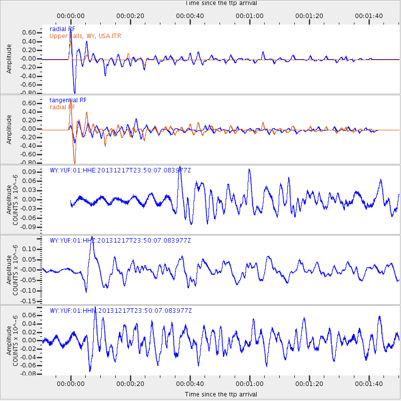
Signal To Noise
| Channel | StoN | STA | LTA |
| WY:YUF:01:HHZ:20131217T23:50:07.083977Z | 3.1577053 | 2.1690106E-8 | 6.868946E-9 |
| WY:YUF:01:HHN:20131217T23:50:07.083977Z | 1.9568549 | 1.1129912E-8 | 5.6876526E-9 |
| WY:YUF:01:HHE:20131217T23:50:07.083977Z | 1.7247974 | 1.4961827E-8 | 8.674542E-9 |
| Arrivals |
| Ps | 5.4 SECOND |
| PpPs | 19 SECOND |
| PsPs/PpSs | 25 SECOND |


