You are here: Home > Network List > TA - USArray Transportable Network (new EarthScope stations) Stations List
> Station V60A Jim Taylor Road, Stokes, NC, USA > Earthquake Result Viewer
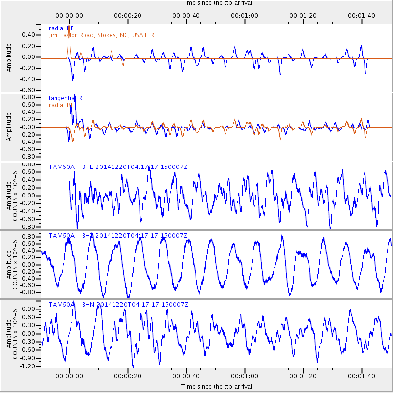
V60A Jim Taylor Road, Stokes, NC, USA - Earthquake Result Viewer
*The percent match for this event was below the threshold and hence no stack was calculated.
| Earthquake location: |
Central Italy |
| Earthquake latitude/longitude: |
43.6/11.2 |
| Earthquake time(UTC): |
2014/12/20 (354) 04:07:04 GMT |
| Earthquake Depth: |
7.4 km |
| Earthquake Magnitude: |
3.4 mb, 3.5 ML |
| Earthquake Catalog/Contributor: |
ISC/ISC |
|
| Network: |
TA USArray Transportable Network (new EarthScope stations) |
| Station: |
V60A Jim Taylor Road, Stokes, NC, USA |
| Lat/Lon: |
35.76 N/77.26 W |
| Elevation: |
8.0 m |
|
| Distance: |
65.5 deg |
| Az: |
296.656 deg |
| Baz: |
52.974 deg |
| Ray Param: |
$rayparam |
*The percent match for this event was below the threshold and hence was not used in the summary stack. |
|
| Radial Match: |
45.32842 % |
| Radial Bump: |
400 |
| Transverse Match: |
87.95334 % |
| Transverse Bump: |
400 |
| SOD ConfigId: |
3390531 |
| Insert Time: |
2019-04-15 16:49:13.175 +0000 |
| GWidth: |
2.5 |
| Max Bumps: |
400 |
| Tol: |
0.001 |
|
Signal To Noise
| Channel | StoN | STA | LTA |
| TA:V60A: :BHZ:20141220T04:17:17.150007Z | 2.925565 | 5.8601046E-7 | 2.0030677E-7 |
| TA:V60A: :BHN:20141220T04:17:17.150007Z | 1.8840555 | 5.4474805E-7 | 2.8913587E-7 |
| TA:V60A: :BHE:20141220T04:17:17.150007Z | 0.78020364 | 2.0325686E-7 | 2.605177E-7 |
| Arrivals |
| Ps | |
| PpPs | |
| PsPs/PpSs | |


