You are here: Home > Network List > II - Global Seismograph Network (GSN - IRIS/IDA) Stations List
> Station PFO Pinon Flat, California, USA > Earthquake Result Viewer
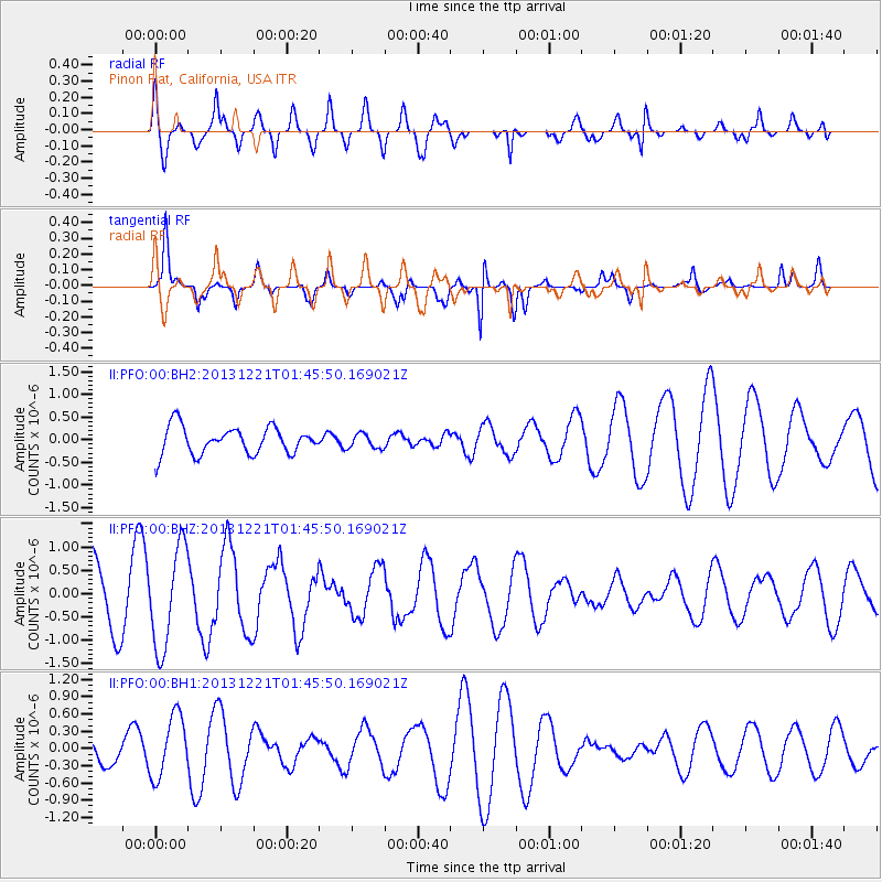
PFO Pinon Flat, California, USA - Earthquake Result Viewer
*The percent match for this event was below the threshold and hence no stack was calculated.
| Earthquake location: |
Near East Coast Of Honshu, Japan |
| Earthquake latitude/longitude: |
35.6/140.6 |
| Earthquake time(UTC): |
2013/12/21 (355) 01:34:13 GMT |
| Earthquake Depth: |
35 km |
| Earthquake Magnitude: |
5.5 MWB, 5.6 MWC |
| Earthquake Catalog/Contributor: |
NEIC PDE/NEIC COMCAT |
|
| Network: |
II Global Seismograph Network (GSN - IRIS/IDA) |
| Station: |
PFO Pinon Flat, California, USA |
| Lat/Lon: |
33.61 N/116.46 W |
| Elevation: |
1280 m |
|
| Distance: |
80.4 deg |
| Az: |
55.604 deg |
| Baz: |
306.32 deg |
| Ray Param: |
$rayparam |
*The percent match for this event was below the threshold and hence was not used in the summary stack. |
|
| Radial Match: |
74.56343 % |
| Radial Bump: |
400 |
| Transverse Match: |
84.882965 % |
| Transverse Bump: |
323 |
| SOD ConfigId: |
626651 |
| Insert Time: |
2014-04-20 02:31:42.869 +0000 |
| GWidth: |
2.5 |
| Max Bumps: |
400 |
| Tol: |
0.001 |
|
Signal To Noise
| Channel | StoN | STA | LTA |
| II:PFO:00:BHZ:20131221T01:45:50.169021Z | 1.6940849 | 1.0777234E-6 | 6.361684E-7 |
| II:PFO:00:BH1:20131221T01:45:50.169021Z | 1.4216777 | 5.442385E-7 | 3.8281425E-7 |
| II:PFO:00:BH2:20131221T01:45:50.169021Z | 0.5415782 | 1.6222202E-7 | 2.9953574E-7 |
| Arrivals |
| Ps | |
| PpPs | |
| PsPs/PpSs | |


